
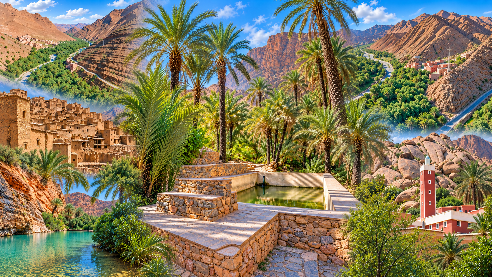
Palm-filled Aït Mansour Gorges framed by ochre Anti-Atlas rock in southern Morocco

Visit / Place · Anti-Atlas · Tiznit province

Aït Mansour Gorges A canyon oasis where water, cultivation and rock share one narrow corridor

South of Tafraout, the Aït Mansour valley cuts a green passage through the arid Anti-Atlas, bringing palm groves, irrigated plots and inhabited slopes into one remarkable landscape.

Read the transition carefully: exposed rock gives way to shade, cultivation and water at the valley floor. The contrast is dramatic, but the oasis is also a working landscape shaped by local knowledge.

Why Aït Mansour Gorges matters

The gorge is a living water landscape.

The cliffs make the first impression, but they do not explain the place on their own. Aït Mansour matters because the narrow valley brings geology, water, cultivation and settlement into direct contact. Palm groves and small fields occupy the lower corridor while bare, deeply folded slopes rise above them.

The valley lies in the commune of Afella Ighir near Tafraout, in Tiznit province. Regional tourism authorities describe a sinuous Anti-Atlas gorge with villages on the surrounding slopes and a palm grove cultivated with palms, almond and olive trees.

Water is the organising force. Gravity-fed irrigation distributes a scarce resource through cultivated ground, making the green valley floor intelligible as a managed agricultural space rather than an accidental patch of vegetation.

The wider Ait Souab–Ait Mansour area is part of an argan-based agro-sylvo-pastoral system recognised by the Food and Agriculture Organization as a Globally Important Agricultural Heritage System since 2018. The designation concerns the broader agricultural system and the knowledge that sustains it, not the gorge in isolation.

For visitors, this changes the way the canyon should be read. The most valuable view is not simply rock against palms, but the relationship between arid slopes, productive ground, water channels, settlements and generations of adaptation to difficult terrain.

Factual context is grounded in the FAO profile of the Ait Souab–Ait Mansour agricultural heritage system and the Souss-Massa Regional Tourism Development Company. Check road, weather and access conditions locally before travel.
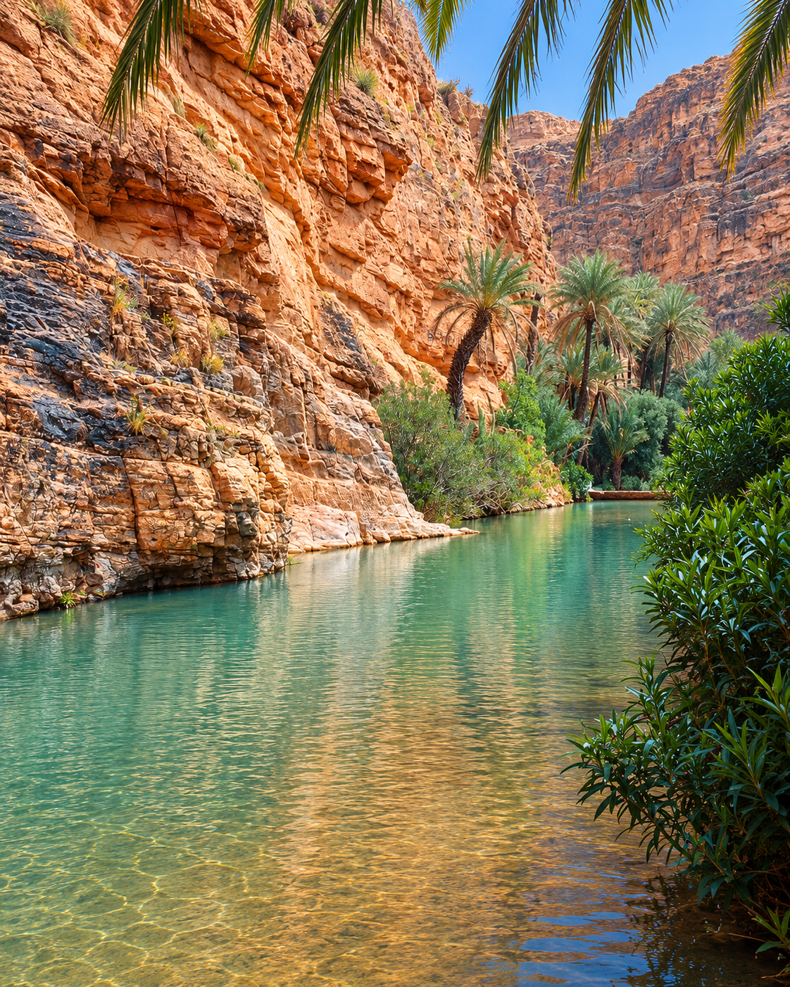
Water, palms and ochre cliff walls inside Aït Mansour Gorges

Map orientation

Use the map to place the gorge within the mountain landscape south of Tafraout; verify current road conditions locally.

Editorial reading

The canyon is a cross-section of adaptation.

Begin with the vertical contrast. The gorge walls compress the view, yet the cultivated floor opens a second landscape beneath them: palms, fruit trees, plots, water and buildings gathered where the terrain allows.

Then read the green corridor as evidence. In an arid mountain setting, vegetation records access to water, irrigation work and continued care. Its presence is beautiful precisely because it is organised and maintained.

The road and paths reveal another layer. They connect fields and settlements while negotiating bends, rock faces and narrow ground. Movement through the gorge is therefore part of the landscape reading, not merely a way to reach a viewpoint.

Some cultivated areas and buildings belong to local residents. Their visual appeal does not make them public space. A careful visitor observes from appropriate routes, asks before photographing people and keeps irrigation channels and field edges undisturbed.

Look for changes in scale: a distant cliff face becomes a textured wall; a palm canopy becomes shade; a bright strip of water becomes part of a working distribution system. These transitions give the gorge its depth.

The strongest memory is the relationship between elements that appear opposed but depend on one another: hard rock and planted ground, exposure and shade, steep slopes and controlled water, dramatic scenery and everyday agricultural life.

Historical and heritage orientation

Read the valley through water, cultivation and continuity.

Aït Mansour is not defined by one monument or a single historic date. Its significance rests in a living landscape where mountain terrain, scarce water, agriculture and community knowledge have been negotiated over time.

01Place type

An oasis gorge

A narrow Anti-Atlas valley holds a cultivated corridor between arid slopes. The site is both a natural landform and an inhabited agricultural landscape.

02Water

Gravity-fed cultivation

Regional sources describe small fields irrigated by gravity. Water distribution helps explain where palms and crops can grow and why the lower valley has a different rhythm from the exposed slopes.

03FAO · 2018

A broader heritage system

FAO designated the argan-based agro-sylvo-pastoral system of Ait Souab–Ait Mansour as globally important agricultural heritage, recognising resilient land use and traditional knowledge.

04Continuity

A working landscape

Fields, irrigation, settlements and routes remain functional parts of the valley. Respectful tourism should support that continuity rather than treat the gorge as empty scenery.

A visual bridge

Three readings between rock, water and settlement

The gorge becomes more legible when its dramatic scenery is separated into three connected systems. Rock sets the limits, water supports cultivation, and settlement follows the narrow ground between them.

01

Scale

Rock as the frame

Steep slopes and narrow passages control the first view. Their height is understood most clearly by comparing them with palms, houses and the road at the valley floor.

  • Use vegetation to measure the walls.
  • Watch colour change across folded rock.
  • Notice where the corridor tightens and opens.
02

Water

The productive valley floor

The green corridor is not separate from the gorge's identity. Irrigation, fields and trees show how water is directed through limited cultivable ground.

  • Look for channels and plot boundaries.
  • Read palms as shade and cultivation.
  • Keep clear of working water systems.
03

Continuity

Settlement follows the route

Buildings and cultivated edges occupy the ground available between rock and water. Their position turns the canyon from a scenic passage into a lived valley.

  • Distinguish public routes from private ground.
  • Observe how buildings meet the slopes.
  • Let local movement take priority.

Quick orientation

Type of place

An oasis gorge and living agricultural valley in the commune of Afella Ighir, Tiznit province.

Landscape context

A narrow Anti-Atlas corridor where arid rock walls meet palms, small irrigated plots and settlements.

Best for

Landscape reading, careful photography, oasis agriculture, mountain routes and slow observation.

Closest city context

Tafraout is the clearest base for understanding the gorge within the wider Anti-Atlas landscape.

What visitors experience here

A landscape that tightens, cools and turns green.

Aït Mansour is experienced as a sequence rather than a single panorama. Open mountain views narrow into rock walls; hard sunlight gives way to palm shade; cultivated ground appears along the water corridor; and each bend rearranges the balance between cliff, road, field and settlement.

Arrival

From open slopes to enclosure

The approach establishes the contrast. Broad, exposed mountain surfaces gradually give way to a confined corridor where cliff walls occupy more of the sky.

Light

Colour moving across rock

Ochre, rose, brown and grey appear as the sun catches different folds. Shade does not flatten the canyon; it reveals ledges, fractures and depth.

Water

A green line through stone

Palms and cultivated plots track the lower ground, making water visible through vegetation, field boundaries and irrigation rather than through spectacle alone.

Movement

Bends set the rhythm

The gorge cannot be absorbed at once. Each turn closes one view and opens another, encouraging pauses where stopping is safe and walking is appropriate.

Sound

A quieter interior

Within the palm corridor, wind in fronds, water movement and local activity replace the exposed silence of the surrounding slopes.

Perspective

Scale through comparison

Cliffs feel largest when read beside trees, buildings and cultivated ground. Human-scale elements make the canyon's vertical proportions understandable.

Place details and orientation

Read Aït Mansour through six defining elements

The gorge is most coherent when its physical and human features are read together. Each element explains how a narrow mountain valley can remain productive and inhabited.

1
Canyon walls

Steep, exposed slopes define the valley's narrow profile and create a strong sequence of enclosure, shadow and changing scale.

2
Palm corridor

Date palms mark the cooler, cultivated floor and give vertical rhythm beneath the far larger rock faces.

3
Irrigation and plots

Gravity-fed water and small field boundaries reveal how limited cultivable ground is organised and maintained.

4
Argan landscape

The gorge belongs to the wider Ait Souab–Ait Mansour agricultural system in which argan-based land use is central.

5
Settled slopes

Buildings and villages occupy viable ground around the valley, making human presence part of the landscape's structure.

6
Route and bends

The path through the gorge follows its constraints. Changing direction continually alters what can be seen and how the place is understood.

Landscape, not backdrop

The gorge asks for a connected reading.

Start with the widest safe view. Identify the exposed slopes, the green lower corridor and the points where buildings meet cultivated ground. This establishes the valley as one system before individual details draw attention.

Move closer to the working scale. Irrigation edges, palms, field walls and paths show how people use narrow ground without separating agriculture from the mountain setting.

Finally, look back toward the rock. The canyon's drama becomes more meaningful once its height is connected to the water and labour below. Aït Mansour is memorable because natural limits and human adaptation remain visible in the same frame.

Landscape and water intelligence

Greenery here is organised, not accidental.

The visual contrast between dry rock and dense palms is created by access to water, cultivable ground and continued maintenance. Regional sources identify gravity-fed irrigation as a defining part of the valley's small agricultural plots.

Across the broader Ait Souab–Ait Mansour system, FAO documents dry-stone terraces, locally adapted crops, pastoral activity and underground water tanks known as matifyia. These practices belong to a wider resilient landscape; visitors should not assume every element appears at every point in the gorge.

What to notice slowly

  • Trace the boundary between bare slope and cultivated ground.
  • Notice how palm shade changes temperature, colour and sound.
  • Look for plot edges and water channels without stepping into them.
  • Compare the scale of cliffs with trees, buildings and the route.
  • Observe how settlements occupy small areas of viable ground.
  • Treat fields, water systems and private buildings as working spaces.

Visual reading

Three landscape languages to notice

Vertical frame

The canyon walls organise the composition before any detail appears. Their folds, ledges and shadow lines produce depth, while the narrow strip of sky reinforces enclosure.

Productive green

Vegetation is not a decorative band. Palms, orchards and plots describe water access and agricultural use, turning colour into evidence of how the valley functions.

Edges and transitions

The most revealing places are boundaries: rock meeting field, shade meeting glare, settlement meeting slope, and irrigation meeting cultivated ground.

Visual atmosphere

From mountain exposure to oasis shade

From ridge to corridor

At wider scale, the Anti-Atlas appears dry and open. Inside the gorge, the view compresses and attention shifts to cliff faces, palms, field edges and the narrow route between them.

From glare to shade

Exposed rock can hold intense light while the palm canopy filters it into broken patterns below. This change in brightness is one of the valley's clearest spatial signals.

From image to understanding

The classic photograph is a band of green between ochre walls. The lasting memory is more precise: water directed through scarce ground, cultivation held beneath rock, and a lived valley continuing inside a dramatic landform.

Nearby places and onward links

Connect the gorge to the wider Anti-Atlas map

Tafraout provides the clearest city context for Aït Mansour. From there, the wider journey can expand through mountain landscapes, regional routes and other carefully documented Visit places.

Tafraout

The nearest city guide and the strongest base for reading the gorge within the granite and mountain landscapes of the Anti-Atlas.

Open Tafraout city guide

Regions of Morocco

Place Aït Mansour within Morocco's wider regional geography before connecting it to another mountain or southern route.

Explore the regions

Landscape themes

Continue through Exotic Morocco's thematic reading of mountains, water, agriculture, settlement and environmental care.

Browse Morocco themes

Visit Morocco places

Discover other valleys, gorges, oases, caves, coasts, monuments and natural sites beyond the city guides.

Browse Visit places

Plan your journey

Build the gorge into a realistic route while leaving room for local advice, changing road conditions and a slower pace.

Plan your journey

Stories from Morocco

Read longer-form work on landscapes, communities, materials and the knowledge that keeps places meaningful.

Read stories

How to visit respectfully

Protect the water, fields and local rhythm.

Aït Mansour is a lived and cultivated valley. Stay on appropriate public routes, keep irrigation channels clear, avoid entering fields or picking produce, and never assume that a building, garden or shaded enclosure is open to visitors.

Respect extends to movement. Narrow roads and paths may serve residents, agricultural work and through traffic. Stop only where it is safe and permitted, keep noise low, take litter away and avoid placing equipment where it obstructs access.

  • Ask clearly before photographing people, homes, work or private land.
  • Do not step into irrigation channels, cultivated plots or fragile field edges.
  • Give residents, agricultural vehicles and local traffic priority.
  • Carry drinking water and sun protection without relying on facilities being available.
  • Check current weather, road and access conditions locally before setting out.

A strong first visit

Begin before the gorge fully closes around the route. From a safe stopping point, identify the dry mountain surfaces and the first signs of the green corridor. This gives the visit a clear visual beginning.

Inside the valley, reduce the pace. Notice where palms follow water, where plots occupy level ground and where rock controls the road. Walk only where access is clear, and keep private land distinct from visitor space.

Use each bend as a new reading rather than searching for one perfect viewpoint. The changing balance between rock, shade, water and settlement is the experience itself.

Finish by reconnecting the gorge to Tafraout and the broader Ait Souab–Ait Mansour agricultural landscape. That context prevents the oasis from being reduced to a scenic anomaly.

  • Read the contrast between exposed slopes and the cultivated floor first.
  • Pause only where stopping is safe, permitted and unobtrusive.
  • Keep water channels, plot edges and access routes untouched.
  • Photograph landscapes without intruding on people or homes.
  • Return through Tafraout with a clearer sense of Anti-Atlas scale.

Careful planning note: road, weather and access conditions can change. Verify current arrangements locally and do not rely on unconfirmed opening, timing or facility information.

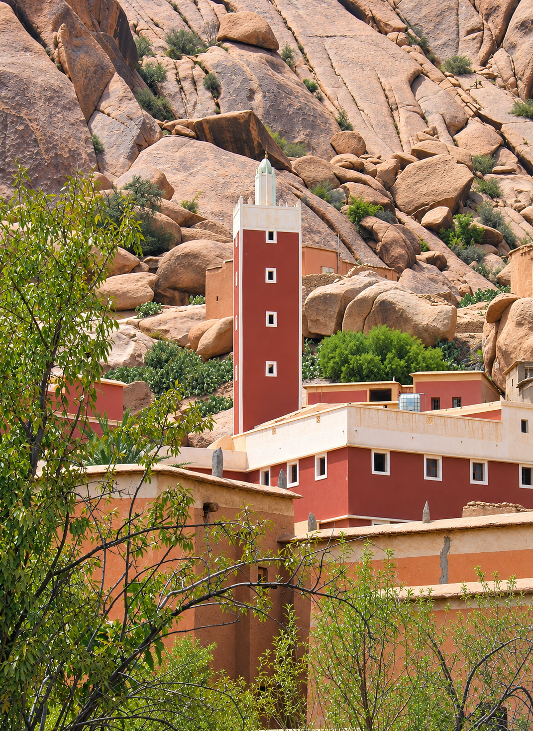
Tafraout mosque and village architecture set against rounded Anti-Atlas granite

Go deeper through the nearest city context

Tafraout — the city gateway to Aït Mansour Gorges

Tafraout is the clearest base for placing Aït Mansour within the Anti-Atlas. Its surrounding valleys, granite forms and settled mountain landscape prepare the eye for the sharper enclosure and oasis agriculture of the gorge.

Use the city guide to organise the wider context: local orientation, mountain routes, the Ameln Valley, landscape character and a slower approach to places whose meaning lies beyond a single photograph.

Anti-Atlas contextTafraout city orientation Valley and mountain routesLandscape and settlement reading Practical travel structureNearby regional highlights

Continue the journey

Continue from Aït Mansour into the Anti-Atlas.

Carry the gorge's lessons—rock, water, cultivation and restraint—back to Tafraout and into the wider landscape map of Morocco.