
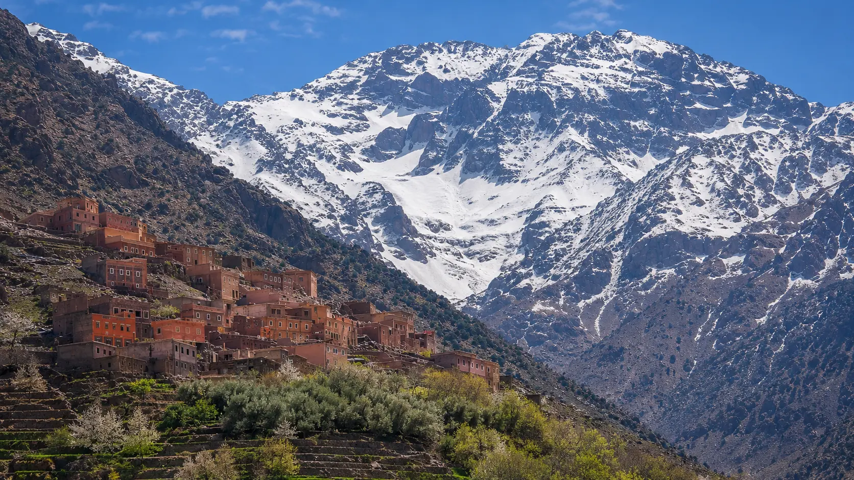
Snow-capped Mount Toubkal rising above Imlil village terraces in Morocco's High Atlas

Visit / Place · High Atlas · Al Haouz province

Mount Toubkal & Imlil Morocco's high mountain gateway between village terraces, snow and stone

Mount Toubkal and Imlil bring the High Atlas into one clear visitor story: North Africa's highest summit, a mountain village threshold, cultivated slopes, footpaths and a landscape that rewards preparation.

Start with Imlil before thinking only of the summit. The village, terraces and surrounding slopes explain the mountain at human scale, while Toubkal itself gives the whole valley its vertical authority.

Why Mount Toubkal & Imlil matter

A summit before it is a trophy.

Mount Toubkal matters because it gives Morocco's High Atlas a visible high point without reducing the mountains to one dramatic number. The summit rises to 4,167 metres, widely recognised as the highest peak in North Africa, but the place is best understood through the valley system below it: Imlil, footpaths, terraces, water, rock, snow and local mountain work.

Imlil matters because it turns altitude into lived geography. It is a village gateway where travellers begin to understand scale before entering higher terrain. The mountain is not approached from nowhere; it is reached through a human landscape of homes, small guesthouses, mule paths, cultivated slopes and seasonal rhythms shaped by the High Atlas.

The wider setting belongs to Toubkal National Park, where Moroccan tourism material presents the area as one of the country's major mountain and nature experiences. This context changes the tone of a visit. Toubkal is not only a climb; it is protected mountain scenery, watershed country, village-edge travel and a place where weather, altitude and terrain deserve respect.

For many visitors, Marrakech provides the city threshold and Imlil provides the mountain threshold. That contrast is part of the power of the journey: the colour, sound and density of the city give way to river valleys, stone paths, terraced green, snow lines and the slower discipline of walking.

A strong visit therefore asks for more than summit ambition. It asks visitors to read the mountain from below, notice village life without intruding on it, move with a guide where appropriate, respect local homes and trails, and treat the High Atlas as a living landscape rather than a scenic backdrop.

Core orientation is grounded in Moroccan National Tourism Office material on High Atlas geography and climbing Mount Toubkal from Imlil. Practical details such as access, conditions, guide requirements and route safety should be checked close to travel.
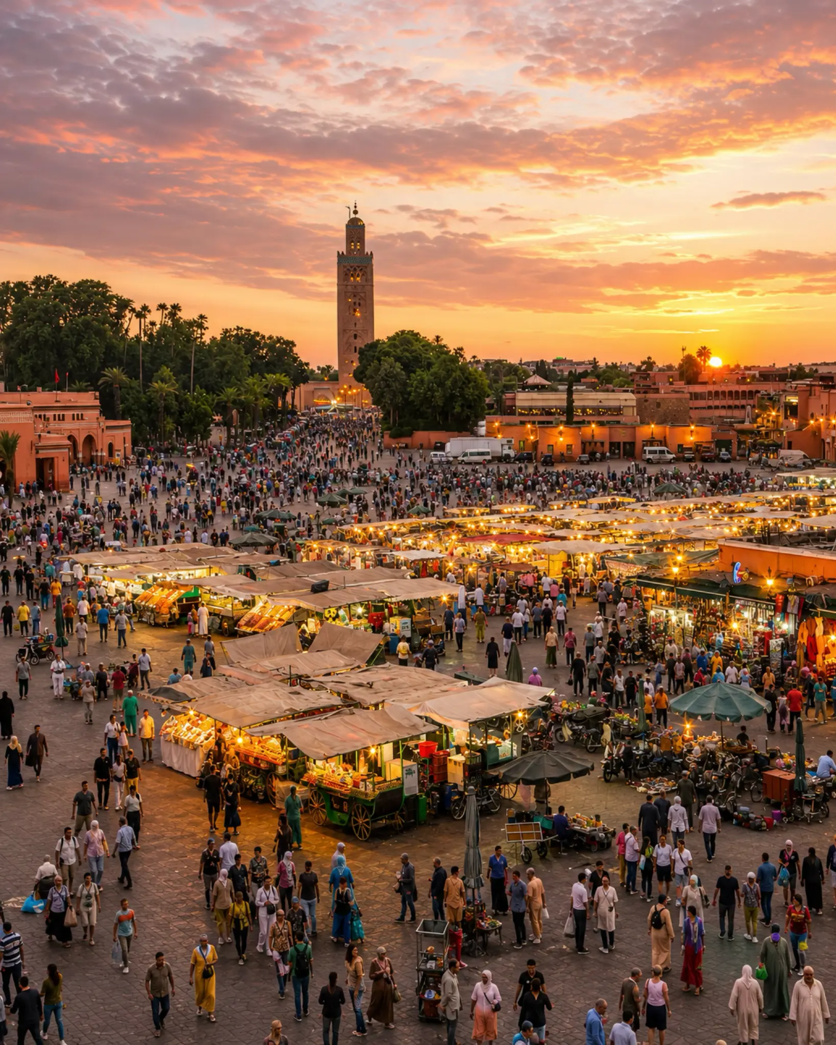
Marrakech at sunset, the city gateway for travellers continuing toward Imlil and Mount Toubkal

Map orientation

Use the map to place Imlil beneath the Toubkal massif, then read the mountain route in relation to Marrakech, Al Haouz and the High Atlas valleys.

Open in Google Maps

Editorial reading

The drama is vertical, but the meaning is local.

The first impression is height: white ridges, dark rock, tight valleys and a summit that seems to pull the whole landscape upward. Look longer and the place becomes more precise. Terraces hold green against stone. Paths connect homes to fields and higher routes. Imlil gives the mountain a social edge.

That is why Toubkal should not be read only as a physical challenge. The better experience holds two scales together: the vastness of the High Atlas and the small decisions that make a mountain visit respectful, safe and memorable.

The strongest visual reading starts in the village. Rooflines, cultivated steps, irrigation channels, trees and track surfaces prepare the eye for the ascent. The summit may be the headline, but the valley teaches visitors how to look.

Light changes the place quickly. Snow can sharpen the upper ridges, haze can soften the valleys, and late sun can bring warmth into stone and earth. A good visitor notices those shifts instead of rushing past them.

Respect matters because mountain beauty is never empty. People live, work, guide, farm, host and move through these valleys. A camera should never turn that life into a display, and a route should never be treated as private adventure detached from the community around it.

Read Toubkal in layers: Marrakech as city threshold, Imlil as village threshold, the lower valley as cultural landscape, and the higher route as terrain where altitude, weather and preparation become serious.

The memory that lasts is not only the peak. It is the moment the village terraces sit below snow, the sound drops away, and the mountain starts to feel less like a destination than a complete High Atlas world.

Historical and landscape orientation

Read the place through altitude, village life and protected mountain terrain.

Mount Toubkal and Imlil belong to a High Atlas landscape where geology, water, agriculture, movement and mountain hospitality meet. The summit gives the place international recognition, but the visitor experience is shaped just as strongly by Imlil's role as a trailhead, the surrounding Amazigh villages and the national park context that frames the higher terrain.

01Place type

Mountain summit and village gateway

This is not a single viewpoint. It is a mountain place where the summit, Imlil, trails, terraces and local services work together as one visitor landscape.

02Altitude

4,167 metres

Mount Toubkal rises to 4,167 metres, making it the highest peak in North Africa. That altitude gives the journey its drama and its need for careful preparation.

03Park context

Toubkal National Park

The mountain sits within Morocco's best-known High Atlas national park setting, a protected landscape of valleys, ridges, trees, seasonal snow and high-country routes.

04Local continuity

Amazigh mountain life

Imlil and nearby villages make the visit more than scenery. They show how settlement, agriculture, guiding, hospitality and movement are tied to mountain conditions.

A visual bridge

Three readings between village, valley and summit

Before Toubkal becomes a climb, it is a relationship between cultivated lower slopes, steep geology, snow-bright ridges and the village threshold of Imlil. These three readings help visitors see the place with more patience.

01

Scale

Height before speed

The mountain's height is visible long before the route becomes demanding. Let the eye climb first: village, terraces, dark rock, snow line and the upper mass of the High Atlas.

  • Read the full ridge before focusing on the trail.
  • Notice where snow and rock sharpen the skyline.
  • Understand scale as atmosphere and responsibility.
02

Water

Terraces and valley logic

Imlil's lower landscape is not decoration below the mountain. Cultivated terraces, trees and water channels show how people have made life possible at the edge of steep terrain.

  • Look for green steps against stone slopes.
  • Read water as part of the mountain story.
  • Give private fields and homes real distance.
03

Looking

City threshold, mountain threshold

Marrakech gives the route its urban beginning, but Imlil changes the tempo. The best visitor lets the journey slow down before the higher paths begin.

  • Use Marrakech as context, not as the whole story.
  • Let Imlil set the pace of the visit.
  • Photograph the landscape without crowding local life.

Quick orientation

Type of place

A High Atlas mountain place combining Morocco's highest summit, Imlil village, national park terrain, trail culture and valley agriculture.

Landscape context

The experience sits south of Marrakech in the High Atlas, where steep rock, seasonal snow, terraced slopes and river valleys shape the visual rhythm.

Best for

Mountain scenery, serious walking, village-edge orientation, photography, slower High Atlas travel and visitors who want landscape with cultural context.

Closest city context

Marrakech is the natural city gateway for travellers who want to connect the medina, Al Haouz routes and the mountain threshold around Imlil.

What visitors experience here

A place that changes with altitude.

Mount Toubkal and Imlil work in layers. First comes the village against a wall of mountains. Then the eye starts reading terraces, trees, paths and snow lines. Higher up, the landscape becomes more mineral, quieter and more exposed, with scale replacing ornament.

Arrival

Imlil below the peaks

The first strong image is not the summit alone. It is the village sitting beneath high ridges, where earth-coloured buildings and green terraces make the mountains feel both immense and inhabited.

Light

Snow, stone and blue air

Light behaves differently here. Snow can make the upper slopes feel sharply drawn, while the lower village holds warmer tones of earth, tree and cultivated ground.

Movement

The measured rhythm of walking

The mountain visit works best when the pace is deliberate. Paths, steps and valley turns slow the body and make the landscape easier to understand.

Texture

Terraces against rock

Look for contrast: soft green terraces against rough slope, village walls against dark mountain, water traces against dry stone and distant snow above cultivated ground.

Altitude

Preparation becomes visible

Higher terrain changes the mood of the visit. Weather, fitness, water, clothing, route knowledge and local guidance become part of the experience rather than details to solve later.

Pace

A quieter mountain memory

The strongest memory may come after the busiest view: a pause on a path, a terrace below the ridge, evening light on Imlil, or the moment the mountain stops feeling like a target and becomes a place.

Place details and orientation

Read Mount Toubkal and Imlil through six defining elements

No single view explains the place. Its meaning comes from the relationship between village threshold, terraced slopes, water, trail systems, protected mountain terrain and the summit's high-altitude scale.

1
Imlil village threshold

Imlil is where many visitors shift from road travel to mountain rhythm, with local guides, guesthouses, paths and village movement shaping the start of the experience.

2
Terraced lower slopes

The cultivated slopes around the village show how mountain life works with limited flat land, seasonal water and careful use of elevation.

3
Trail culture

Footpaths, mule routes and guided walking are part of the place's practical intelligence. They connect homes, fields, passes and higher mountain routes.

4
Toubkal National Park context

The higher landscape should be approached as protected mountain terrain, not as an empty adventure playground. Staying on appropriate routes matters.

5
Snow and seasonal contrast

Snow changes the visual reading of the massif and can change conditions quickly. The same place can feel open, severe, green or austere depending on season and altitude.

6
The 4,167-metre summit

Toubkal's summit gives the landscape its vertical meaning, but altitude also asks for respect: preparation, weather awareness and local route knowledge are part of the visit.

Mountain, not backdrop

The place asks for a prepared eye.

Stand in Imlil before reading the high ridges. The first lesson is scale: a village held in a steep valley, green terraces below snow, and a mountain wall that makes distance feel immediate.

Then move closer to the details. Track surfaces, irrigation lines, stone edges, rooflines, trees and footpaths make the mountain human again. They show that the High Atlas is not only a view from a distance, but a working landscape with its own order.

If your route continues higher, let the lower valley remain part of the story. The summit has meaning because it rises from lived geography: Imlil, neighbouring villages, trail knowledge, seasonal weather and the discipline of moving carefully through altitude.

Landscape and route intelligence

Mountain beauty is not a shortcut.

The beauty of Toubkal and Imlil comes from the relationship between height, water, rock, settlement and movement. Terraces soften the valley, snow sharpens the upper massif, and the route from Marrakech to Imlil gives visitors a dramatic change of scale.

That beauty also brings responsibility. Altitude, weather and terrain can change the visit quickly, while village life deserves privacy and patience. The best planning treats the mountain as real terrain and the village as a living community, not a staging area for a photograph.

What to notice slowly

  • Look at Imlil's position before focusing on individual trails or summit images.
  • Notice where terraces, trees and water soften the lower mountain landscape.
  • Read snow and exposed rock as signals of altitude, weather and preparation.
  • Keep local homes, fields and working paths visually present but personally respected.
  • Use Marrakech as route context, then let the High Atlas set a slower pace.
  • Check current mountain conditions and local guidance before committing to higher routes.

Visual reading

Three mountain languages to notice

Vertical scale

Toubkal speaks through height: lower village, rising slopes, snow lines and upper rock. The visual power depends on seeing these layers together.

Water and terraces

Imlil's green steps explain how people read the mountain practically. Water, cultivation and slope are part of the landscape's intelligence.

Route and restraint

The mountain route rewards care. Preparation, local guidance, weather awareness and respect for village spaces are part of the visual and ethical reading.

Visual atmosphere

Snow, stone and quiet transitions

From distance to detail

Start with the full mountain wall, then move closer to read village edges, terraces, trees, paths and the changing texture of rock. The shift from wide view to local detail is what makes the place feel complete.

From stone to snow

The strongest contrast is natural: dark ridges, white snow, warm village walls, green cultivated steps and clear High Atlas air. Nothing needs to be exaggerated when the layers are allowed to speak.

From image to memory

The photograph may begin with the peak, but the memory often settles in smaller moments: a quiet path, evening light over Imlil, the sound of water, or the feeling of altitude arriving gradually.

Nearby places and onward links

Connect Toubkal and Imlil to the wider Morocco map

Mount Toubkal and Imlil belong naturally to a Marrakech and High Atlas journey. Use the city, the mountain region and the Visit section to build a route that respects both landscape and pace.

Marrakech

The closest major city context for many travellers heading toward Imlil. Use it to frame the shift from medina density to mountain air and Al Haouz valley routes.

Open Marrakech city guide

Atlas, Interior & Mountain Morocco

The regional home for High Atlas landscapes, mountain routes, interior valleys and places where altitude shapes culture, agriculture and travel rhythm.

Explore the region

Themes

Use the themes section to connect mountain scenery with Moroccan landscape, heritage, craft, food, architecture and slower cultural travel.

Browse themes

Visit Morocco places

Continue through waterfalls, valleys, caves, oases, monuments, lagoons and natural heritage places beyond the city guides.

Browse Visit places

Plan your journey

Treat Imlil as a mountain threshold, not a rushed add-on. Build the route around weather, walking level, local guidance and enough time to slow down.

Plan your journey

Stories from Morocco

Use the Stories section for richer cultural reading around landscape, memory, routes and the human rhythm behind Morocco's most powerful places.

Read stories

How to visit respectfully

Good preparation protects the experience.

Mount Toubkal and Imlil reward visitors who arrive with humility. The landscape is beautiful, but altitude, weather, route choice and village privacy all matter. Treat local advice as part of the visit, not as an obstacle to it.

Respect also means understanding that Imlil is not a stage set at the foot of a famous peak. People live and work here. Move carefully through village spaces, ask before photographing people, keep fields and homes private, and support local services with courtesy.

  • Ask clearly before photographing local people, guides, muleteers, homes or private workspaces.
  • Keep to appropriate routes and avoid shortcuts that damage terraces, paths or fragile slopes.
  • Carry suitable water, layers and sun protection, and check current mountain conditions before higher walks.
  • Use qualified local guidance where the route, season, altitude or your experience level makes it sensible.
  • Pack out litter, keep noise low and leave space for local movement through narrow paths.

A strong first visit

Begin with Imlil itself. Let the first hour be about orientation: where the village sits, where the terraces climb, how paths leave the settlement, and how the Toubkal massif frames the valley from above.

If you continue walking, keep the route honest. Match the plan to fitness, weather, season and daylight, and do not treat a high mountain route as a casual city excursion. The most confident visit is usually the best prepared one.

Listen for the practical words that organise the landscape: pass, refuge, valley, terrace, snow line, guide, weather, water and return. These words make the view readable and help prevent the visit from becoming only a photograph.

Afterward, connect the mountain back to Marrakech and the wider High Atlas. The contrast helps the place settle in memory: city heat and colour, valley roads, cultivated slopes, stone paths and the cool authority of the upper ridge.

  • Start in the village, where the mountain has human scale.
  • Let terraces, water and path direction explain the lower landscape.
  • Use viewpoints to understand altitude and valley shape, not only to photograph the panorama.
  • Leave space for local movement, guides, mules, small businesses and residents.
  • Finish by connecting Imlil back to Marrakech and the wider High Atlas region.

Careful planning note: route access, weather, guide arrangements and mountain conditions can change. Verify practical arrangements locally before travelling.

Marrakech at sunset, the city gateway for travellers continuing toward Imlil and Mount Toubkal

Go deeper through the nearest city context

Marrakech — the city gateway to Mount Toubkal and Imlil

Mount Toubkal and Imlil belong naturally inside a wider Marrakech journey. The city gives visitors a strong contrast before the mountains: medina rhythm, garden shade, food, craft, public squares and the sudden visual pull of the Atlas beyond the city.

Use Marrakech to frame the transition, then let Imlil change the pace. The stronger route does not rush from city to summit; it lets the High Atlas become legible through valley roads, village terraces, walking routes and careful mountain preparation.

City gateway contextMarrakech orientation High Atlas route planningImlil village threshold Mountain preparationSlower cultural travel

Continue the journey

Continue from Imlil into mountain Morocco.

Read the High Atlas slowly, then connect Mount Toubkal to Marrakech, Al Haouz valleys, mountain routes and the wider landscape map of Morocco.