Tazekka National Park Forests, caves, ridges and blue mountain water above Taza
Tazekka National Park protects one of Morocco's most layered mountain landscapes: Atlas cedar, oak woodland, karst caves, springs, limestone ridges, Jbel Tazekka and the city gateway of Taza.
Start with the open landscape before chasing individual sights. The park is strongest when water, forest, rock and height are read together: a mountain system where the surface view and the underground world belong to the same story.
Tazekka matters because it gathers several Moroccos into one compact protected landscape. Above Taza, the park moves from cedar and oak forest to limestone ridges, springs, seasonal water, cave openings and high viewpoints. It is not a single attraction; it is a natural system.
The protected area was created in 1950 around Jbel Tazekka and later expanded to more than 13,000 hectares. That history matters because the park was not created only for scenery. It exists to protect mountain forest, water retention, karst geology, wildlife habitat and the fragile balance between human access and ecological care.
The cave world gives the park a second, deeper identity. Friouato is often treated as the headline, but the cave should be read as part of a wider karst landscape: water moving through limestone, chambers shaped over time, underground coolness beneath sunlit forest and a sense of depth that changes the way the mountains above are understood.
Tazekka also gives Taza a powerful natural context. The city is not just a stop on the way to somewhere else; it is the gateway to a mountain park where forest shade, rock, water and high air sit close to urban history and the routes between northern and interior Morocco.
For visitors, the best experience is not speed. It is a careful sequence: read the map, notice the ridge, enter the forest slowly, respect cave guidance, keep water and weather in mind, and leave the place as clean and quiet as you found it.
Core park facts are grounded in the official Tazekka National Park site. Practical details such as cave access, prices, weather, route conditions and guide availability should be checked close to travel.
Map readingTazaJbel TazekkaKarst caves
Map orientation
Use the map to read the park as a mountain landscape south of Taza, with Jbel Tazekka, forest routes and cave country connected in one protected area.
Editorial reading
Forest above, cave below, water between.
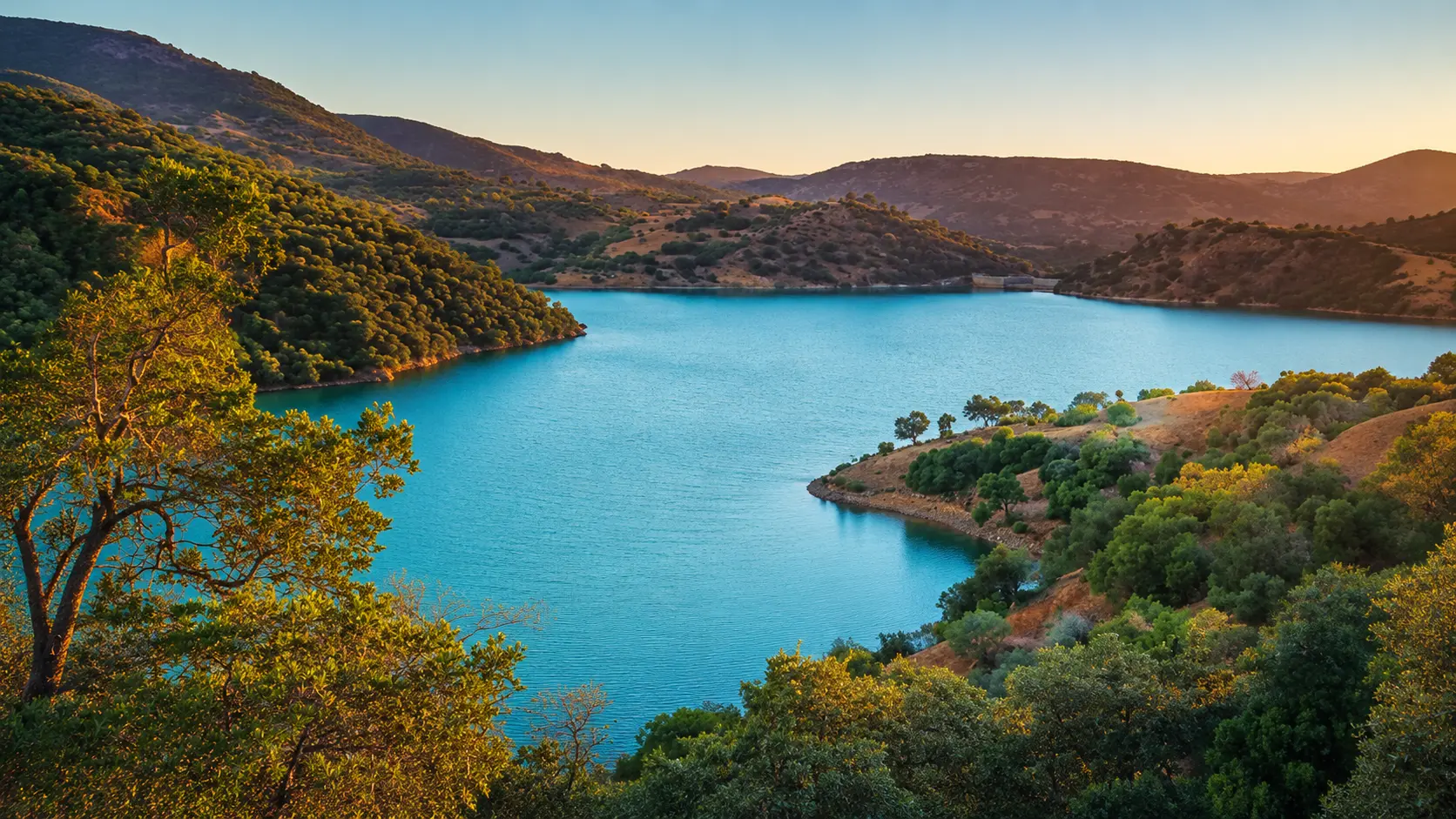
The beauty of Tazekka is vertical. On the surface, the park opens as a bright mountain landscape: green slopes, pale rock, blue water and warm evening light. Below that surface, limestone has been shaped into chambers, narrow passages and cool underground space.
That double reading gives the park its force. The cave is not separate from the forest; the forest is not separate from water; the water is not separate from the limestone that stores, filters and releases it. The visitor who understands that connection sees more than a pretty view.
Look first for transitions. Open slopes give way to shaded woodland. Dry rock suddenly meets clear water. A road viewpoint can feel wide and sunlit, then a cave entrance turns the same landscape inward, mineral and quiet.
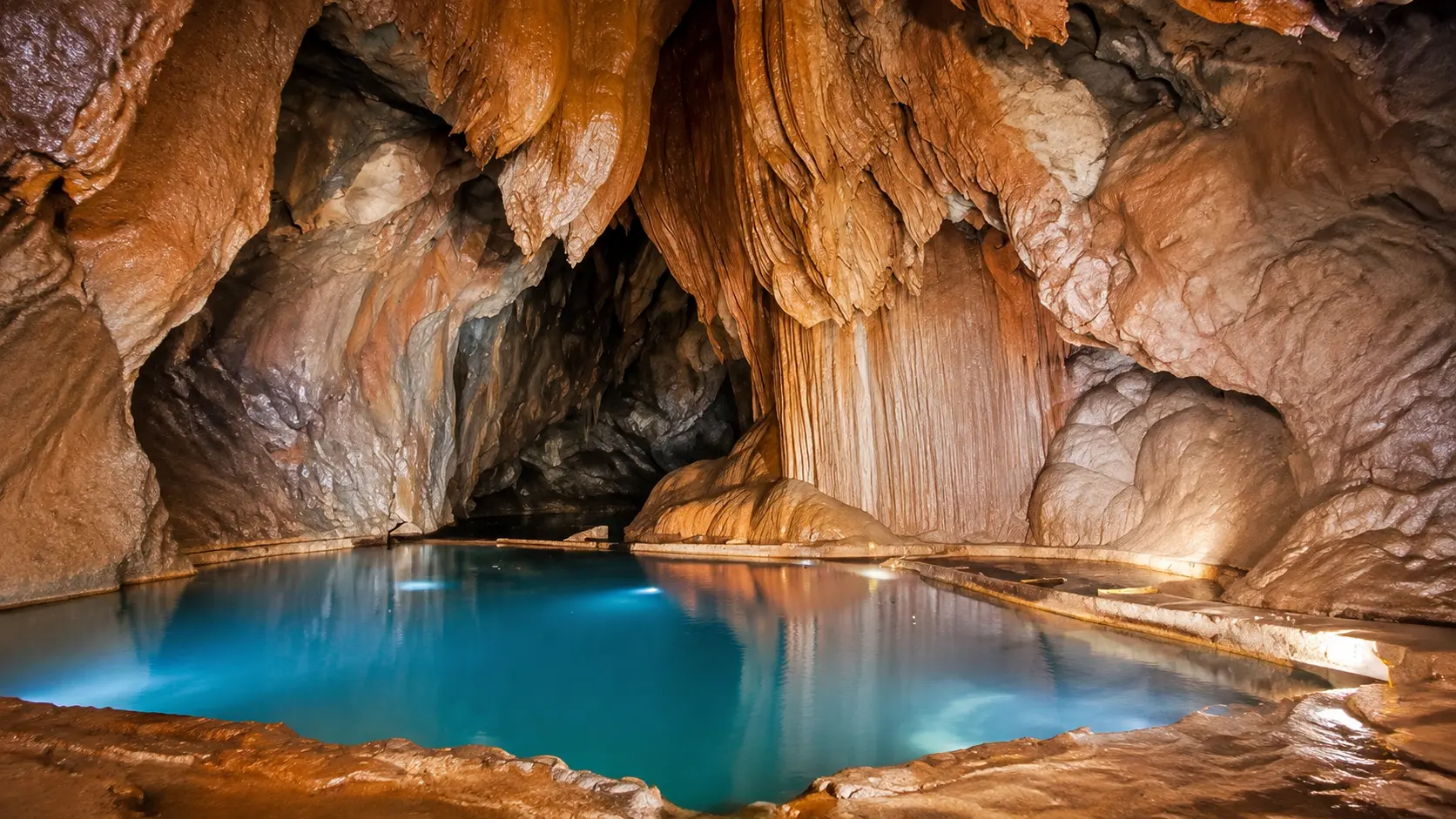
The cave image belongs here because it shows the hidden half of the park. Stalactite forms, wet surfaces and blue reflections make the underground world feel almost architectural, but the intelligence is geological: water, pressure, mineral time and protected darkness.
Tazekka should therefore be photographed with restraint. Wide hero views are powerful, but detail matters too: cedar needles, stone texture, rippled water, damp cave walls, ridge lines and the way light falls differently above and below ground.
The richer visit keeps both moods alive: the openness of a mountain sunset and the intimacy of a cave chamber. Together they make Tazekka feel less like a checklist and more like a compact lesson in Moroccan landscape depth.
Protected landscape orientation
Read the park through protection, geology and mountain water.
Tazekka is a natural heritage landscape, not a monument. Its importance comes from the relationship between protected forest, Jbel Tazekka, karst caves, springs, slopes, seasonal coolness and the city of Taza below. The strongest reading connects ecology, geology and visitor responsibility.
011950
Protection begins
The park was created as a protected area around Jbel Tazekka, with particular attention to the Atlas cedar landscape that makes the mountain so distinctive.
021989
A wider mountain mosaic
The protected area was expanded to include a broader system of forests, limestone formations, caves, springs and rural mountain landscapes.
031,980 m
Jbel Tazekka as anchor
Jbel Tazekka gives the park its vertical identity. The summit area helps explain the cooler air, moisture, forest cover and wide views over the Taza region.
04Karst
The cave landscape
Friouato and the surrounding limestone features reveal the hidden structure of the park. Access conditions can change, so cave visits should be planned with current local guidance.
A visual bridge
Three readings between forest, rock and water
Before Tazekka becomes a photograph, it is a relationship between visible landscape and hidden geology. These readings help visitors slow down and understand why the park feels open, cool, deep and mineral at once.
01
Forest
Cedar and oak as structure
The forest is not background scenery. It gives the park shade, moisture, habitat and scale, and it turns the mountain into a living protected system rather than a bare viewpoint.
Notice where dense shade changes the temperature.
Read cedar, oak and undergrowth as part of one habitat.
Keep noise low so the forest rhythm stays intact.
02
Karst
Depth beneath the path
The cave country changes the way the surface is seen. Limestone, water and underground passages make Tazekka a place of depth, not only height.
Treat cave access as guided and condition-dependent.
Never touch mineral formations or wet cave surfaces.
Read underground water as part of the mountain system.
03
Light
Blue water and high air
The hero view works because warm light, cool water and dark green slopes hold each other in balance. Tazekka is a lesson in contrast without visual noise.
Start wide, then move toward smaller details.
Watch how water changes the colour of the valley.
Use viewpoints to understand the park, not only to shoot it.
Quick orientation
Type of place
Protected mountain park near Taza, best understood through forest, karst geology, water systems, viewpoints and quiet nature-based travel.
Landscape context
The park sits around Jbel Tazekka in the Middle Atlas, close to the northern mountain routes and the historic city gateway of Taza.
Best for
Cedar and oak forest, cave atmosphere, blue mountain water, landscape photography, geology, calm walking and a cooler contrast to busier routes.
Closest city context
Taza gives the clearest base for reading the park: old city fabric below, mountain roads above and caves deeper inside the landscape.
What visitors experience here
A park that changes as you move through it.
Tazekka works in stages. First comes the wide mountain view: water, slopes and sky. Then the forest tightens the experience. After that, cave country turns the landscape inward, where mineral surfaces, damp air and shadow make the same place feel entirely different.
Arrival
Blue water below the slopes
The first visual hit is often colour: turquoise water, dark green vegetation, pale rock and open sky. The contrast feels almost coastal, but the setting is inland and mountainous.
Forest
Cedar shade and oak texture
The wooded sections slow the visit down. Shade, resin, leaf noise and uneven ground make the park feel protected and alive, not simply scenic.
Cave
Friouato's underground scale
The cave context adds drama without needing exaggeration. Mineral curtains, wet rock, blue reflections and cool air turn the park from an exterior landscape into an interior one.
Height
Jbel Tazekka viewpoint logic
Higher ground helps visitors understand the park's structure. Forest, ridges, water and Taza's wider region begin to read as connected layers rather than isolated stops.
Quiet
Water, wind and distance
The soundscape is part of the experience: wind through trees, water movement, occasional voices near stopping points and long quiet stretches where the mountain feels spacious.
Pace
A route for slow attention
The park is better with margin. Weather, light, access and cave conditions can shape the day, so the strongest visit leaves room to pause, turn back, ask locally and look longer.
Place details and orientation
Read Tazekka through six defining elements
No single detail explains the park. Its meaning comes from the relationship between mountain height, forest, karst depth, water, cave access and Taza as the natural city gateway.
1
Jbel Tazekka
The mountain gives the park its name, height and orientation. It is the anchor for forest, viewpoints, moisture and wider landscape reading.
2
Cedar and oak forest
Atlas cedar, oak woodland and mountain vegetation create the protected green character that separates Tazekka from drier lowland scenery.
3
Friouato cave context
The cave landscape is one of the park's defining experiences, but it should be approached through current safety guidance and local expertise.
4
Limestone and karst
The rock matters. Caves, sinkholes, chambers and underground water all point to a landscape shaped from within as much as from above.
5
Springs and seasonal water
Water gives the park its colour and ecological value. Streams, springs and blue surfaces should be treated as fragile, not decorative.
6
Taza gateway
Taza frames the visit with city context, food, roads, older urban fabric and the practical rhythm of entering the mountain zone.
Mountain, not backdrop
The park asks for a careful eye.
Stand back before entering the details. The first lesson is spatial: water held between slopes, forest spreading across ridges, pale limestone catching light and roads threading the protected area without explaining it fully.
Then move closer. Leaves, needles, damp stone, cave walls, small paths and shaded pauses make the park intimate again. This is where the visit becomes more than a panorama: the eye starts to understand how moisture, rock and vegetation hold the place together.
Keep returning to the connection between surface and depth. Tazekka is memorable because it offers both the outward image of a mountain park and the inward experience of cave geology.
Landscape and ecological intelligence
The park's beauty is a working system.
Tazekka is beautiful because its parts do real work. Forest cools and protects slopes. Limestone stores and releases water. Caves reveal underground movement. Springs and seasonal flows support life below the ridges. Viewpoints help visitors see the system at scale.
This is why the park should not be treated like a simple photo stop. A careless visit can damage the very qualities people come to admire: cave formations, clean water, forest quiet, fragile soil, roadside vegetation and the calm needed for wildlife and local use.
What to notice slowly
Look at the whole valley shape before focusing on individual viewpoints.
Notice where forest shade, open rock and water colour change the mood.
Read cave surfaces as protected formations, not objects to touch.
Keep Jbel Tazekka in mind as the park's visual and climatic anchor.
Connect Taza below with the mountain roads and forest above.
Respect signs, local guidance and seasonal conditions before entering caves or remote paths.
Visual reading
Three natural languages to notice
Surface and depth
The visible park is only half the story. Forest, road and water sit above a limestone world where caves and underground movement shape the landscape from below.
Green and mineral
Cedar and oak soften the mountain, while rock gives it edge. Tazekka works visually because vegetation and geology remain in constant conversation.
Access and restraint
The park invites exploration, but the best visitor reads limits as part of the place: signs, guides, weather, cave safety and the need to leave fragile areas untouched.
Visual atmosphere
Light, texture and quiet transitions
From surface to depth
Start with the whole mountain view, then let the cave image change the reading. The same park that feels open and sunlit above ground becomes enclosed, cool and mineral below.
From green to blue
The strongest visual contrast is the meeting of forest and water. Green slopes hold the frame; blue water opens it; warm rock and sunset light keep the image grounded.
From city to mountain
The memory of Tazekka is stronger when Taza remains in the story. The city gives arrival rhythm; the mountain gives air and depth; together they make the visit feel anchored.
Nearby places and onward links
Connect Tazekka to the wider Taza and mountain map
Tazekka works best when it is connected outward: Taza for city context, the Atlas and interior regions for landscape reading, and the Visit section for Morocco's caves, waterfalls, parks and protected places.
Taza city context
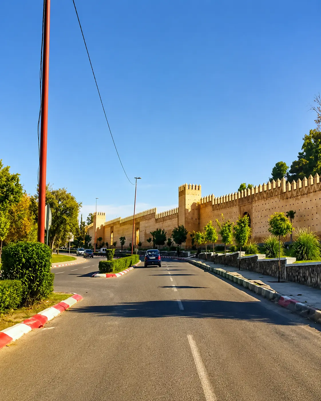
Taza is the natural gateway for the park: old walls, urban rhythm, mountain access and the practical base for reading Tazekka without rushing it.
Good behaviour protects the forest, caves and water.
Tazekka rewards curiosity, but it is still a protected mountain environment. Stay on appropriate routes, keep noise low, avoid litter, respect signs and never treat caves, springs or forest edges as casual playgrounds.
Respect also means planning with humility. Cave access and route conditions can change; weather can shift; mountain roads require patience. Ask locally, follow current guidance and avoid forcing an itinerary when conditions suggest a slower or simpler visit.
Do not touch stalactites, wet cave surfaces or mineral formations.
Carry out all litter and avoid smoking or fire risk in forested areas.
Use local guidance for cave visits, remote tracks and seasonal conditions.
Ask before photographing people, homes, guides or village life around the park.
Carry water, layered clothing and enough daylight margin for a calm return.
A strong first visit
Begin with the map and the skyline. Place Taza below the park, Jbel Tazekka above it and the cave zone within the larger limestone landscape. That first mental map helps the day feel coherent instead of scattered.
Next, give time to the forest. The shaded sections are not filler between viewpoints; they are the living structure of the park. Walk quietly, notice changes in temperature and let the mountain air reset the pace.
If cave access is available and locally advised, treat Friouato as a serious geological place. Go with proper guidance, avoid touching formations and let the cave deepen the visit rather than turning it into a quick thrill.
Afterward, connect the visit back to Taza. The city cover image belongs here because Tazekka is easier to understand when the mountain and the gateway city are held together: old urban walls below, protected landscape above.
Start with the landscape scale before focusing on single stops.
Use forest pauses to notice shade, temperature, sound and texture.
Approach cave spaces only with current local guidance and respect.
Leave springs, paths, rocks and vegetation cleaner than you found them.
Finish by connecting the park back to Taza and the wider mountain region.
Careful planning note: cave access, opening details, prices, weather and road conditions can change. Verify practical arrangements locally before travelling.
Go deeper through the nearest city context
Taza - the city gateway to Tazekka National Park
Tazekka belongs naturally inside a wider Taza journey. The city gives visitors a stronger base for reading the park: older walls, road approaches, local rhythm, mountain access and the sudden shift from urban edge to cedar, limestone and water.
Use Taza to widen the context after the park itself. The route feels richer when the city and mountain are connected: one gives history and arrival, the other gives forest, depth and protected air.
Historic city contextTaza gateway orientationForest and cave routesMountain landscape readingPractical travel structureNearby protected places
Continue from Tazekka into Morocco's mountain map.
Read the park slowly, then connect it to Taza, the Middle Atlas, cave landscapes, forest routes, protected water and the wider natural heritage map of Morocco.