
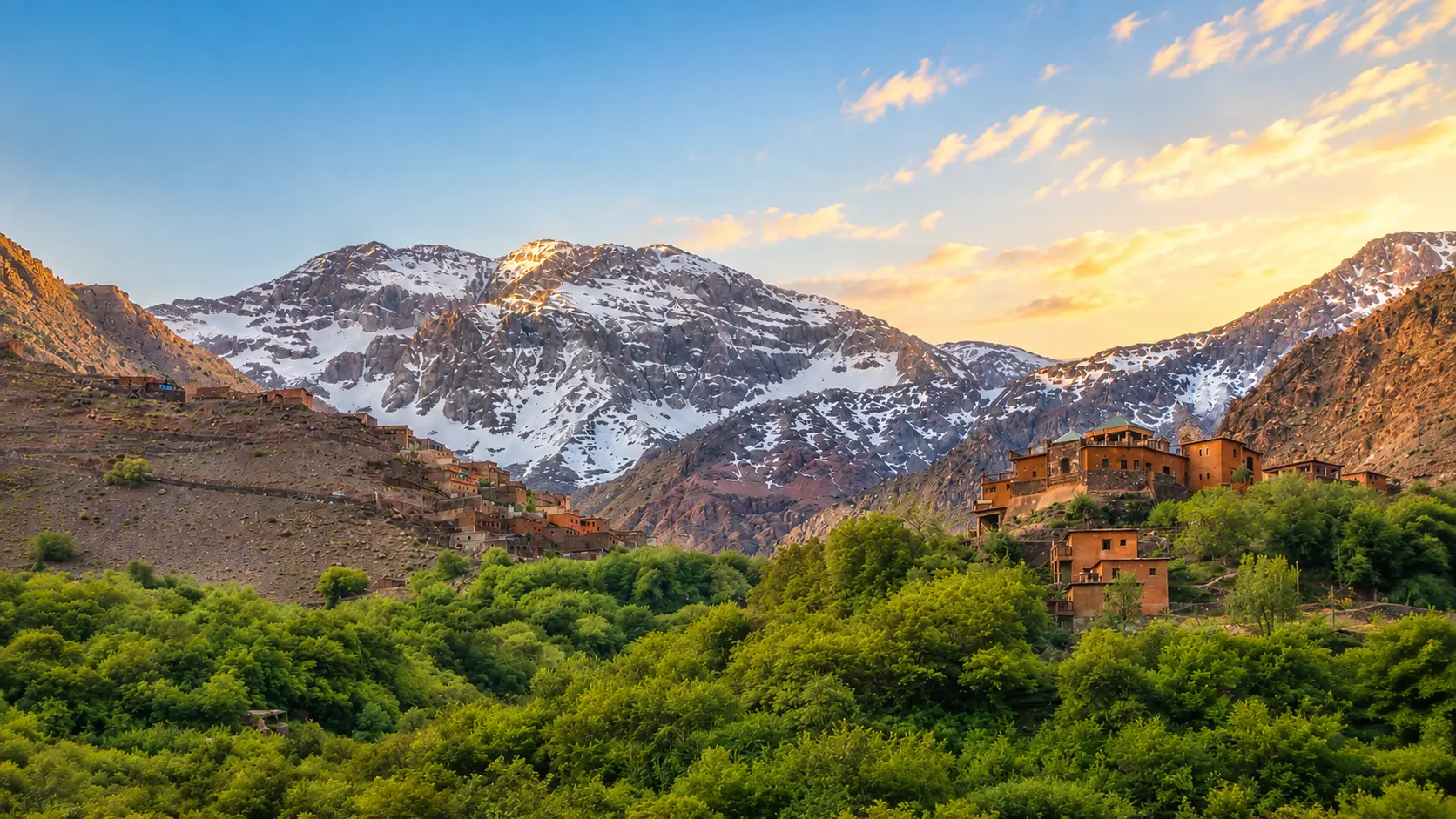
Snow-dusted High Atlas ridges, green valley trees and mountain villages in Toubkal National Park, Morocco

Visit / Place · High Atlas · Marrakech-Safi

Toubkal National Park Morocco's high mountain world of snow, stone, valleys and village paths

Toubkal National Park protects the dramatic High Atlas landscape around Jbel Toubkal, where Morocco's highest mountain rises above terraced valleys, rocky passes and Amazigh mountain communities.

Begin with scale. The strongest first view is not only the summit, but the whole mountain grammar: snow lines, red-brown rock, green valley floors, villages held to slopes, and paths that make the landscape readable.

Why Toubkal National Park matters

A protected mountain landscape before it is a summit photo.

Toubkal National Park matters because it concentrates one of Morocco's clearest mountain readings into a single protected landscape. The park sits in the High Atlas, south of Marrakech, around Jbel Toubkal and the surrounding valleys that give the mountain its human and ecological context.

Authoritative protected-area references identify Toubkal as Morocco's first national park, established in 1942, and describe a mountain area of about 380 square kilometres. Jbel Toubkal, at 4,167 metres, is widely recognised as the highest peak in North Africa. Those facts give the place importance, but they do not fully explain its power.

The deeper meaning is in the relationship between altitude, water, rock and settlement. Snow and high ridges feed streams below; paths connect villages, fields, passes and refuge routes; the vegetation changes as elevation rises; and the same landscape can feel green, mineral, exposed or alpine depending on season and height.

For visitors, the park should not be reduced to a trophy climb. Its strongest experience comes from learning how mountain scale works: distant peaks first, then valley agriculture, village edges, mule paths, stone tracks, shade, water, weather and the discipline required by altitude.

That is why the park rewards slow looking. A visitor who pauses before walking higher sees more than scenery: slope logic, water routes, village placement, seasonal risk and the careful balance between tourism, local life and protected mountain habitat.

Core protected-area facts are grounded in the Global Alliance of National Parks profile, the Protected Planet profile, the U.S. National Park Service sister-park note and the Moroccan National Tourism Office. Exact access, weather, guide requirements and route conditions should be checked close to travel.
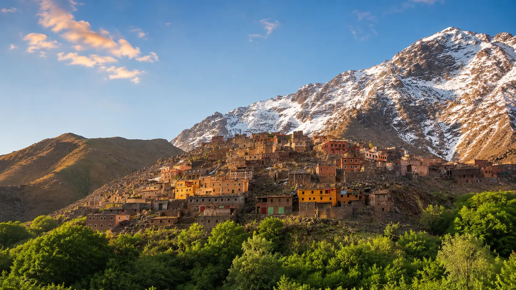
High Atlas village slopes and snow-streaked mountain ridges in the Toubkal landscape

Map orientation

Use the map first to understand the park as a High Atlas landscape south of Marrakech, with Imlil and nearby valleys forming common mountain approach contexts.

Editorial reading

Its beauty is vertical, seasonal and lived.

The park's beauty is not only in one summit line. It is in the way height changes everything: temperature, vegetation, walking pace, sound, shade, water, visibility and the sense of distance between villages.

Look at the lower valley before looking at the highest snow. Terraces, paths and houses show that the mountain is also a lived landscape. The park holds nature and human geography together, which is why the most respectful reading includes both conservation and local rhythm.

The strongest photographs often come from wide perspective, but the strongest memory comes from sequence: green foreground, earth-coloured village, stony track, cold ridge, changing light and the sudden silence that arrives when the landscape opens.

In good conditions, routes can feel direct and open. In poor weather or winter conditions, the same mountains demand caution. That contrast is part of the place's seriousness. A mountain park should invite wonder without encouraging careless confidence.

Read the landscape in layers. Valley floor gives the first grammar: water, cultivation and approach. Slopes explain settlement and effort. Ridges reveal exposure. Snow and cloud remind visitors that the High Atlas is not scenery alone, but a living high-altitude environment.

A good visit keeps admiration and restraint together. Stay on appropriate routes, follow local guidance, protect water and vegetation, and leave enough quiet for the place to remain larger than the image you came for.

Historical and natural orientation

Read the park through protection, altitude and continuity.

Toubkal National Park is best understood as a protected High Atlas landscape rather than a single viewpoint. Its importance comes from high peaks, valleys, water sources, vegetation zones, mountain villages and the long relationship between local communities and the routes that cross this terrain.

01Place type

Mountain national park

The site is a terrestrial and inland-waters protected area in Morocco's High Atlas. Its identity comes from the whole landscape: ridges, valleys, streams, slopes, villages and high mountain routes.

02Protection

Established in 1942

Toubkal is widely cited as Morocco's first national park. That status frames the visit as more than recreation: the landscape is valued for conservation, mountain habitat and water-bearing terrain.

03Highest peak

Jbel Toubkal

Jbel Toubkal rises to 4,167 metres and is recognised as the highest summit in North Africa. The peak gives the park its name, but the surrounding valleys are essential to understanding it.

04Mountain life

Valleys and communities

Amazigh villages, terraced fields and working paths belong to the park's real geography. Visitors should read the mountains as a lived landscape, not as an empty wilderness backdrop.

A visual bridge

Three readings between summit, valley and route

Before Toubkal National Park becomes a mountain image, it is a relationship between height, water, rock and human movement. These three readings help visitors slow down and understand the place beyond the obvious panorama.

01

Altitude

Height changes the visit

Every layer of the park responds to elevation. Valley green, rocky slope, exposed ridge and snowline each create a different kind of light, pace and responsibility.

  • Read vegetation changes as the route climbs.
  • Watch how shade, wind and snow alter the mood.
  • Treat altitude as a condition, not a decoration.
02

Water

Valleys make the mountain legible

Streams, terraces and planted valley floors explain how mountain water supports life below the ridges. The green foreground is not incidental; it is part of the park's meaning.

  • Connect snow and high ridges to valley water.
  • Notice terraced fields and village placement.
  • Keep the lower landscape in the frame.
03

Route

Distance before summit

The strongest reading starts before the climb becomes dramatic. Approach roads, village paths and valley turns prepare the eye to understand scale before the high mountain dominates.

  • Begin with the full valley setting.
  • Let paths reveal scale gradually.
  • Use viewpoints to understand distance, not only height.

Quick orientation

Type of place

A High Atlas national park and protected mountain landscape, best understood through valleys, ridges, villages, water, trekking routes and Jbel Toubkal.

Region or area

The park sits in Morocco's High Atlas, south of Marrakech, with the Marrakech-Safi region providing the clearest travel-base context for most visitors.

Best for

Mountain scenery, careful trekking, valley walking, photography, altitude awareness, nature reading and understanding how High Atlas communities relate to landscape.

Closest city context

Marrakech is the strongest city gateway for wider planning, while Imlil and nearby valleys give the immediate mountain approach context.

What visitors experience here

A mountain park that changes with every layer of height.

Toubkal National Park works in stages. First comes the broad High Atlas wall. Then the eye notices villages, terraces and green valley lines. Higher up, stone, snow, wind and distance begin to dominate. The experience is strongest when those stages are allowed to build slowly.

Arrival

The first mountain wall

From lower ground, the High Atlas reads as a powerful edge. The park begins to make sense when the visitor sees how villages and trees sit below immense rocky slopes.

Light

Snow, rock and late sun

Light changes the mountains quickly. Snowfields brighten the ridges, red-brown rock holds warmth, and the valley floor can remain green while the upper landscape feels almost alpine.

Movement

Paths, turns and effort

The walking rhythm is part of the place. Tracks rise gradually, turn through villages, pass water and shade, then open toward harsher stone and wider mountain air.

Material

Stone before spectacle

The park's texture is mineral: loose stone, ridges, scree, rock walls, dry paths and houses that share the earth tones of the mountain. Detail matters as much as the view.

Weather

Conditions shape meaning

Clear sky can make the landscape feel generous; snow, wind or cloud can make it serious very quickly. Visitors should read weather as part of the mountain, not as an inconvenience.

Pace

A slower kind of ascent

The best visit is not rushed. Pausing in the valley, speaking respectfully with local guides and watching the landscape change creates a deeper memory than chasing only the highest point.

Place details and orientation

Read Toubkal National Park through six defining elements

No single summit explains the park. Its identity comes from the relationship between high ridges, water, villages, trails, seasonal snow and the protected nature of the mountain landscape.

1
Jbel Toubkal

The park's named peak rises to 4,167 metres and anchors the wider mountain landscape, but it should be read together with the valleys below it.

2
High Atlas ridges

Long ridgelines, rocky slopes and changing snow cover give the park its scale and make distance visible before any single detail stands out.

3
Valley water

Streams and green valley floors reveal how high mountain conditions support lower fields, trees and settlement patterns.

4
Village approaches

Imlil and surrounding mountain villages help visitors understand the park as a lived landscape shaped by paths, work, hospitality and local knowledge.

5
Trail rhythm

Walking routes move through scale: shaded lower paths, stone tracks, exposed slopes and higher perspectives that require preparation and attention.

6
Protected habitat

The park's conservation value includes mountain vegetation, birdlife, water sources and fragile high-altitude environments that depend on careful visitor behaviour.

Mountain, not backdrop

The place asks for a disciplined eye.

Stand low before thinking high. The first lesson is spatial: village, valley, slope and ridge belong together. The mountain feels more powerful when the visitor sees how people, water and paths gather below it.

Then let the route narrow. Stone underfoot, turns between houses, cultivated edges, stream sound and changing shade make the park human again. This is where the visit becomes more than a distant peak: the eye starts to understand access, effort and dependency.

Higher perspectives should return the visitor mentally to the valley. Looking down is not only about panorama; it is a way to understand how the High Atlas holds movement, settlement, water and weather inside one dramatic landscape.

Landscape and mountain intelligence

Altitude is not a style effect.

The mountain character of Toubkal National Park is not just visual atmosphere. Elevation changes climate, vegetation, water movement, walking difficulty and visitor responsibility. The landscape is beautiful because it is physically demanding and ecologically layered.

The park's valleys and ridges should be read as one system. Snow and high rock are connected to streams, fields and villages below. That relationship gives the park its intelligence: the summit may dominate the eye, but the valley explains why the mountain matters.

What to notice slowly

  • Look at the whole valley before focusing on the highest peak.
  • Notice where green terraces give way to rock, scree and snow.
  • Distinguish a mountain walk from a summit-focused trophy visit.
  • Read village placement as part of slope, water and route logic.
  • Watch weather and light as active parts of the landscape.
  • Respect fragile vegetation, water edges and working local paths.

Visual reading

Three mountain languages to notice

Scale and exposure

Toubkal National Park speaks first through scale: ridges above ridges, long slopes, sudden weather and a vertical distance that turns ordinary movement into mountain effort.

Water and settlement

The lower landscape explains the higher one. Streams, trees, terraces and villages show how mountain water and local knowledge shape life below the summit.

Path and restraint

Trails invite movement, but the park also asks for restraint. Good route choices, local guidance, quiet behaviour and respect for terrain protect both visitor and place.

Visual atmosphere

Light, stone and quiet altitude

From valley to ridge

Start with the green floor and mountain villages, then let the eye climb toward rock and snow. The shift from cultivated valley to exposed ridge is essential: it turns a beautiful view into a readable mountain landscape.

From stone to sky

The strongest visual contrast is not artificial colour, but the meeting of red-brown slopes, white snow, blue air and the hard line of ridges. Look for how the same mountain can feel warm, cold, dry or luminous within one afternoon.

From photo to memory

The image is powerful, but the deeper memory comes from walking slowly enough to connect summit, route, village, water and weather. A careful visitor leaves with more than one frame: footfall, wind, light, silence and scale.

Nearby places and onward links

Connect the park to the wider High Atlas map

Toubkal National Park belongs to a broader mountain and city journey. Marrakech gives the strongest planning base, while the Atlas region opens toward valleys, passes, villages and slower landscape reading.

Marrakech

The clearest city gateway for Toubkal planning. Use Marrakech to frame the shift from medina intensity to High Atlas valleys, mountain routes and cooler air.

Open Marrakech city guide

Atlas, Interior & Mountain Morocco

The regional home for High Atlas landscapes, interior routes, mountain towns, valleys and the deeper geography behind Morocco's inland journeys.

Explore the region

Themes of Morocco

Use the Themes section for broader reading around landscapes, heritage, craft, food, nature and the cultural patterns that connect place to memory.

Browse themes

Visit Morocco places

Continue through kasbahs, valleys, waterfalls, lagoons, caves, monuments, gardens and natural heritage places beyond the city guides.

Browse Visit places

Plan your journey

Treat Toubkal as a mountain landscape that needs flexible planning, current local guidance, suitable equipment and respect for changing conditions.

Plan your journey

Stories from Morocco

Use the Stories section for richer cultural reading around place, movement, memory, landscapes and the human rhythm behind visual travel.

Read stories

How to visit respectfully

Good mountain behaviour protects the experience.

Toubkal National Park is popular enough to attract quick summit ambitions, but the mountain deserves more care than that. Move with patience through villages, avoid blocking paths, ask before photographing people, and remember that working landscapes are not open sets.

Respect also means caring for terrain. Do not cut fragile slopes, leave litter, damage plants, disturb water edges or underestimate altitude and weather. A slower visitor sees more and creates less pressure on the place.

  • Ask clearly before photographing residents, guides, muleteers, shopkeepers or private spaces.
  • Stay on appropriate routes and follow local guidance, especially beyond valley walks.
  • Carry out litter and protect water sources, trees, terraces and fragile vegetation.
  • Prepare for sun, cold, wind, altitude and fast-changing mountain conditions.
  • Check current route, weather, access and guide advice close to travel.

A strong first visit

Begin in the valley so the park's structure is clear before the high peaks dominate. Villages, trees, terraces and paths show how people and water relate to the mountain, and that first reading gives the visit its depth.

Move slowly enough to notice transitions: green foreground to stone track, village edge to open slope, warm wall to cold ridge, sunlight to shadow. Each change explains more than a rushed summit narrative can.

If you go higher, treat the mountain with seriousness. Weather, snow, altitude and route conditions can change the meaning of a walk quickly. Local guides and current advice are part of responsible travel, not an optional extra for difficult days only.

Afterward, connect the visit back to Marrakech and the wider Atlas region. That wider context helps Toubkal feel less like an isolated challenge and more like part of Morocco's mountain geography, seasonal life and landscape memory.

  • Start with the valley view, where settlement and water make the park readable.
  • Enter mountain routes with patience, suitable preparation and attention to weather.
  • Use viewpoints to understand scale, not only to collect a panorama.
  • Leave space for local movement, guides and everyday village life.
  • Finish by connecting the park back to Marrakech and the High Atlas region.

Careful planning note: exact access, route conditions, weather, guide arrangements and seasonal safety can change. Verify practical details locally before travelling.

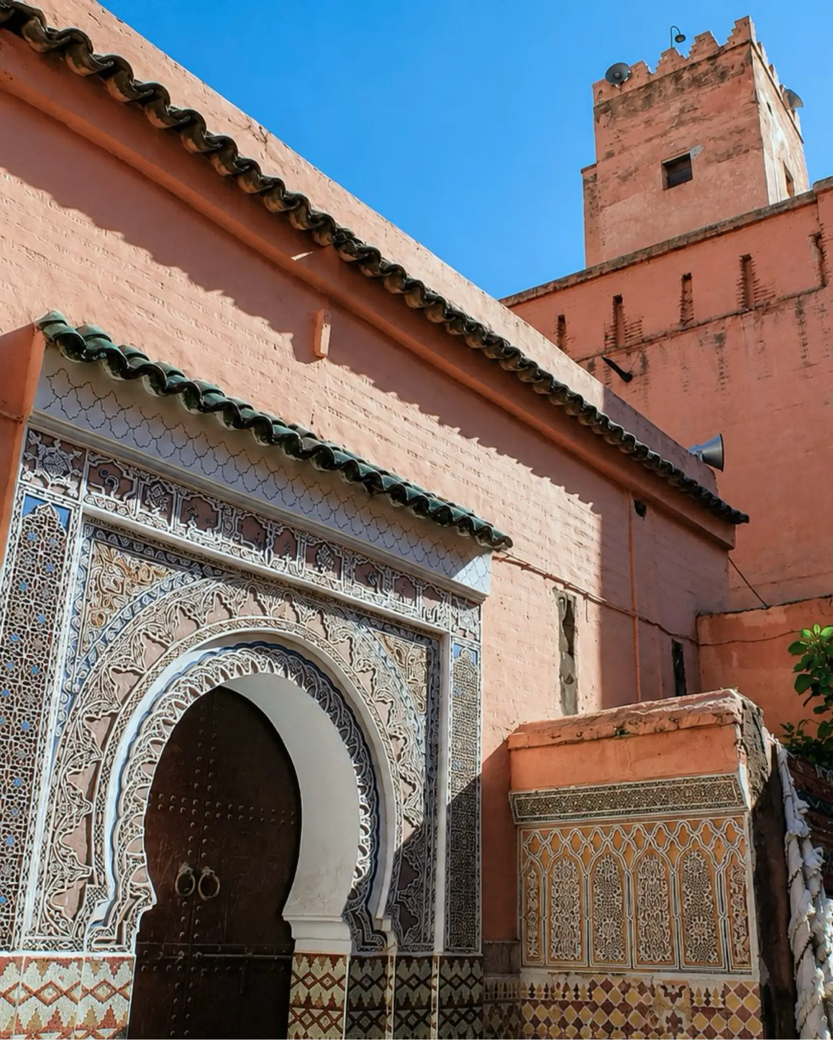
Marrakech architecture with warm rose walls and carved entrance details, the city gateway for Toubkal National Park

Go deeper through the nearest city context

Marrakech - the city gateway to Toubkal National Park

Toubkal National Park belongs naturally inside a wider Marrakech journey. The city gives visitors a strong planning base before the landscape shifts toward High Atlas valleys, village approaches, mountain air and the more demanding rhythm of walking.

Use Marrakech to widen the context after the park itself: medina, gardens, architecture, food culture and Atlas routes all become easier to connect when Toubkal is treated as part of a larger Moroccan journey rather than a single summit ambition.

Marrakech city orientationHigh Atlas gateway Mountain route planningLandscape and culture reading Practical travel structureNearby Atlas context

Continue the journey

Continue from Toubkal National Park into mountain Morocco.

Read the park slowly, then connect it to Marrakech, the High Atlas, valley routes, respectful trekking and the wider landscape map of Morocco.