
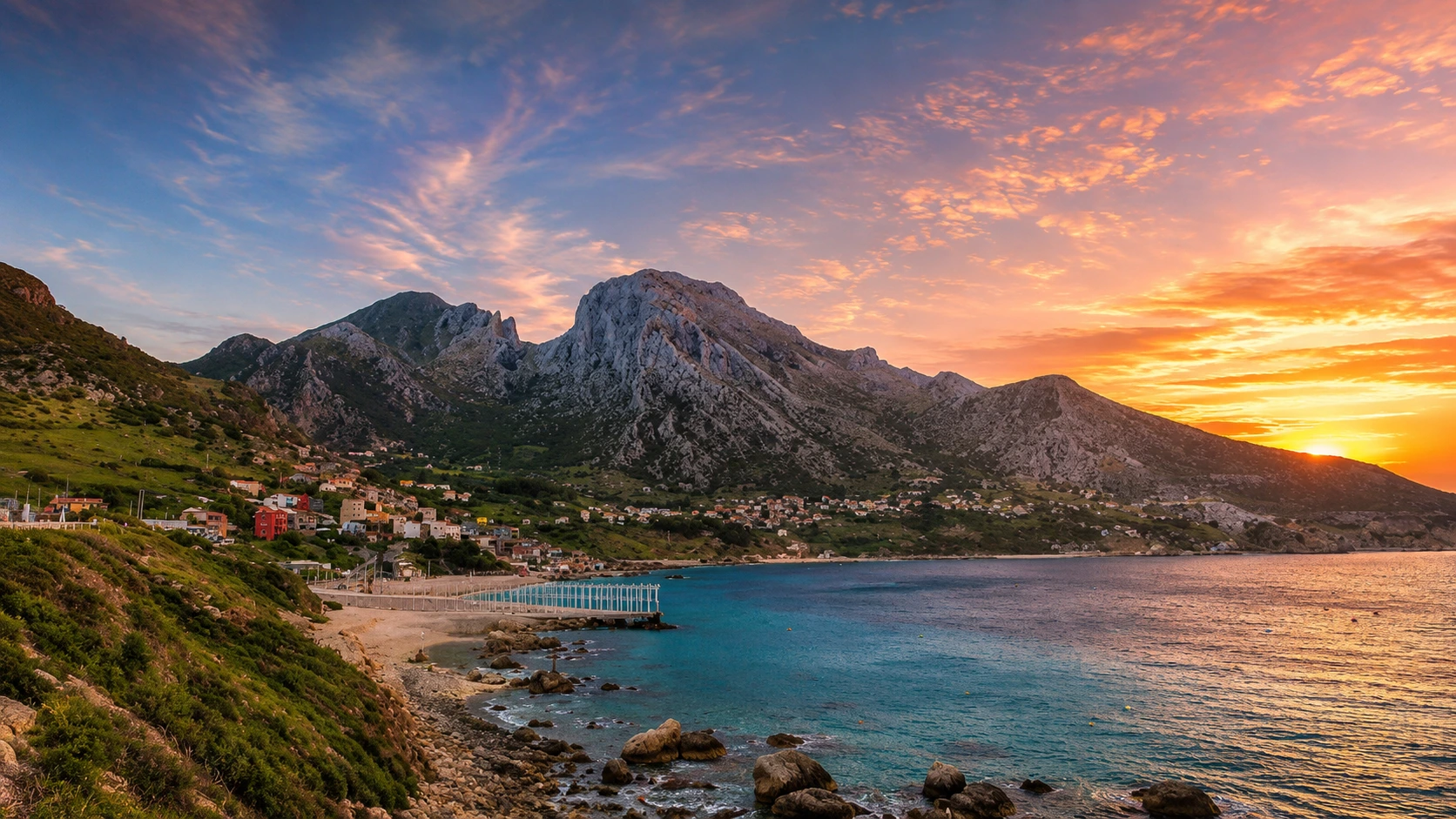
Sunset over Belyounech bay, Jbel Musa and the Strait of Gibraltar coast in northern Morocco

Visit / Place · Belyounech · Jbel Musa · Fnideq coast

Belyounech & Jbel Musa A northern Moroccan meeting of mountain, village and Strait light

Belyounech sits below the limestone mass of Jbel Musa, where the Rif reaches the Strait of Gibraltar and Morocco's coast feels both intimate and immense.

Begin with the whole view: village roofs under steep rock, blue water at the foot of the mountain, the far shore across the Strait and the evening light that makes the coastline feel sharply legible.

Why Belyounech & Jbel Musa matter

A mountain village at one of Morocco's clearest thresholds.

Belyounech and Jbel Musa matter because they make geography visible. Here the northern Rif does not fade gently into the sea; it rises hard above coves, paths, white houses and a shoreline facing the narrow water between Africa and Europe.

The mountain is often written as Jbel Moussa in conservation and scientific sources. Its coastline is internationally recognised through the Ramsar-listed Littoral de Jbel Moussa, and the wider Jbel Moussa area is identified by Key Biodiversity Areas as important for migrating soaring birds using the Strait.

That ecological context changes the way the place should be read. The view is not only scenic. Cliffs, updrafts, coastal vegetation, coves and open water form a working landscape where wind, rock, seasonal movement and local fishing life meet in a narrow space.

Belyounech adds the human scale. The village is not a stage set below the mountain; it is part of the place's rhythm. A good visit moves with care through lanes, viewpoints and shore edges, leaving room for local life while noticing how settlement fits into steep terrain.

For travellers, the strongest reading is slow and layered: first the mountain outline, then the bay, then the path, then the Strait horizon. Jbel Musa feels dramatic from far away, but the intelligence of the place comes from how many scales are held together.

Core ecological facts are grounded in the Ramsar listing for Littoral de Jbel Moussa, the Key Biodiversity Areas factsheet for Jbel Moussa and the UNESCO Man and the Biosphere context for the Intercontinental Biosphere Reserve of the Mediterranean. Practical access conditions should be checked close to travel.
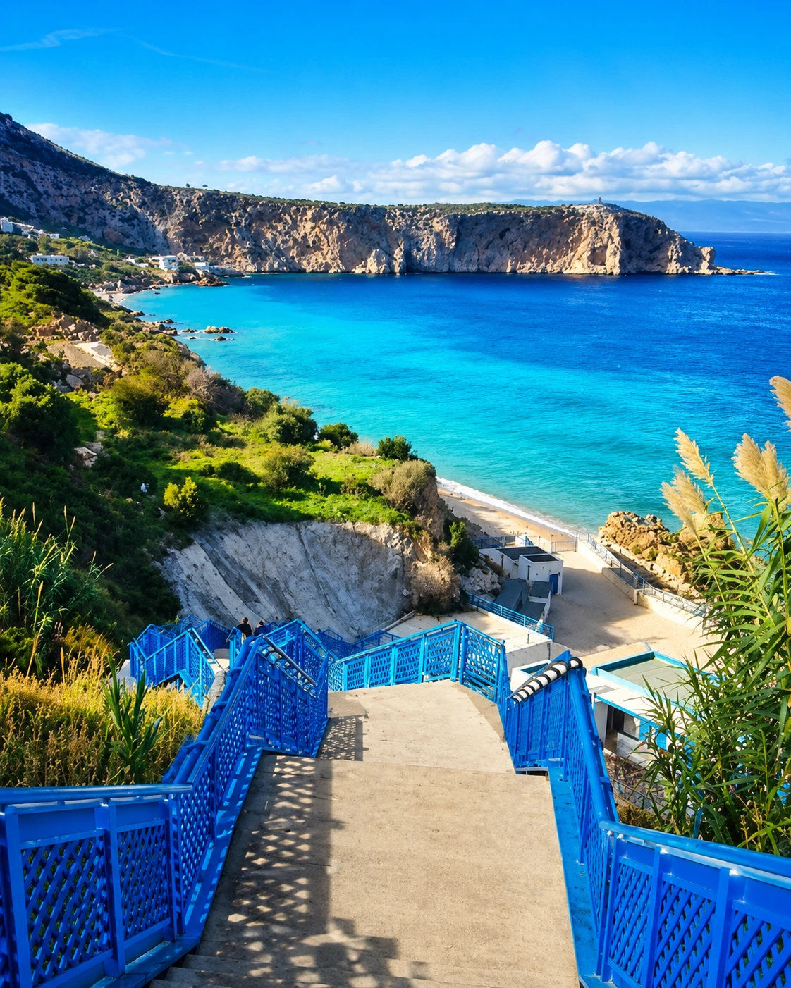
Blue stairs descending toward the clear bay below Jbel Musa near Belyounech

Map orientation

Use the map to read the place as one coastal-mountain system: Belyounech below, Jbel Musa above and Fnideq as the nearest city context.

Editorial reading

Its beauty comes from pressure, scale and restraint.

Jbel Musa is powerful because it rises almost directly from the coastal edge. The mountain compresses the view: village, bay, ridge, cliffs and Strait sit close enough for the eye to understand them together.

The water adds the second layer. It is not background blue. It is the route surface of the Strait, a channel of weather, migration, fishing and long Mediterranean-Atlantic movement. Looking across it changes the mountain from scenery into a marker.

The best photographs are often wide, but the best understanding is patient. Notice how the road bends around the coast, how the village holds to the slope, how rocks cut shadow into the bay and how the sea colour changes near shore.

There is also a quiet discipline to visiting well. Some paths are steep, exposed or rough; some edges are fragile; some village spaces are ordinary local spaces, not visitor sets. The place rewards confidence, but it asks for humility.

Read Jbel Musa from below before thinking about climbing higher. The full profile gives the mountain its meaning, and the village view keeps the visit grounded in the people and coastline that live with the mountain every day.

From Fnideq, the place feels close enough to be tempting as a quick outing. Do not reduce it to that. Give Belyounech and the mountain enough time for arrival, looking, walking, pausing and leaving without pressure.

Historical and natural orientation

Read the site through rock, Strait and living coastline.

Belyounech and Jbel Musa are best understood as a coastal landscape rather than a single viewpoint. The mountain belongs to the northern Rif, the shoreline faces the Strait of Gibraltar, and the area has recognised ecological value through Ramsar and biodiversity designations. The visitor experience should therefore connect scenery with conservation, village life and careful movement.

01Place type

Coastal mountain landscape

The identity comes from the relationship between Belyounech village, Jbel Musa's limestone profile, coves, cliffs, paths and the Strait horizon.

02Geography

Northern Rif edge

The mountain sits in Morocco's far north, where Rif terrain meets the Strait of Gibraltar and coastal movement becomes part of the visual story.

03Ecology

Migration and shoreline value

Jbel Moussa is recognised by Key Biodiversity Areas for its role as a migration bottleneck, especially for soaring birds using air currents near the Strait.

04Care

A protected coast to treat lightly

The Ramsar-listed littoral makes the shoreline more than a beach view. Cliffs, marine edge, vegetation and local use all deserve a visitor rhythm that avoids damage and noise.

A visual bridge

Three readings between mountain, water and village

Before Belyounech becomes a photograph, it is a lesson in thresholds. The place is strongest when visitors read the mountain from distance, the water as movement and the village as the human scale between them.

01

Mountain

Rock as landmark

Jbel Musa gives the coastline its authority. Its pale limestone, broken ridges and steep profile make the village feel sheltered and exposed at the same time.

  • Read the whole outline before seeking detail.
  • Notice cliff shadow, ridge lines and slope texture.
  • Keep the mountain connected to the bay below.
02

Strait

Water as passage

The Strait is not empty space. It is a corridor of weather, light, fishing movement and bird migration, giving the place a sense of openness beyond the village.

  • Watch how colour changes near the shore.
  • Look across the water before turning inland.
  • Read wind and horizon as part of the scene.
03

Village

Human scale under the ridge

Belyounech keeps the landscape from becoming abstract. Houses, lanes, shore edges and small daily movements bring the mountain back to lived ground.

  • Move quietly through residential edges.
  • Give paths and local movement space.
  • Let the village rhythm set the pace.

Quick orientation

Type of place

A coastal village and mountain landscape on Morocco's northern Strait coast, best read through village life, cliffs, water, path and horizon together.

Landscape context

Jbel Musa belongs to the northern Rif edge above Belyounech, where limestone slopes meet coves and the Strait of Gibraltar opens the view northward.

Best for

Coastal mountain views, careful hiking, blue-water photography, Strait orientation, bird-migration context and slow visual reading from village to ridge.

Closest city context

Fnideq is the clearest nearby city base for travellers connecting Belyounech with the Mediterranean coast, Tetouan direction and northern route planning.

What visitors experience here

A place that widens with every step.

Belyounech and Jbel Musa work in layers. First comes the mountain wall above the bay. Then the village appears at human scale. Then the Strait opens the horizon, and the same place starts to feel like a meeting point between shore, road, wind and rock.

Arrival

The village below the mountain

The first impression is vertical: houses and shore held beneath a rock mass that dominates the coastline without erasing the village rhythm.

Water

Blue coves and sharp edges

The coast shifts from open blue to clear shallows, pale rock and small beach edges. Look for the line where mountain shadow changes the colour of the bay.

Walking

Paths that ask for attention

The landscape is rewarding but not casual. Rough ground, exposed light and steep sections mean a careful pace matters more than rushing for a summit view.

Light

Sunset without exaggeration

Late light gives the mountain real depth: grey limestone warms, village walls soften and the Strait reflects colour without needing artificial drama.

Horizon

The far shore in the mind

The Strait gives every view a second geography. Even when the opposite coast is hazy, the sense of crossing, weather and distance remains present.

Pace

A quieter coastal rhythm

The strongest visit leaves space for ordinary life: fishing activity, families, local movement, pauses in shade and the sound of water against rock.

Place details and orientation

Read Belyounech & Jbel Musa through six defining elements

No single viewpoint explains the place. Its meaning comes from the relationship between mountain profile, village settlement, protected shoreline, Strait horizon, walking terrain and Fnideq coastal context.

1
Jbel Musa profile

The mountain gives the page its main visual grammar: pale rock, steep slope, broken ridges and a strong outline visible from the coast.

2
Belyounech village

The village holds the human scale below the ridge, where houses, lanes and local movement make the mountain landscape feel inhabited.

3
Strait viewpoint

The view across the Strait of Gibraltar turns the site into a threshold landscape, not only a beach or mountain stop.

4
Cliffs and coves

Rocky shore edges and clear water give the place its sharp coastal character, especially where shadow, stone and shallows meet.

5
Recognised shoreline

The Littoral de Jbel Moussa Ramsar context helps visitors understand the coast as an ecological edge that should be treated carefully.

6
Fnideq context

Fnideq provides the nearest city frame for approaching the place, connecting Belyounech with the wider Mediterranean north coast.

Mountain, not backdrop

The place asks for a careful eye.

Stand back before choosing where to walk. The first lesson is scale: the mountain does not sit behind Belyounech politely; it shapes the settlement, the light, the road and the feeling of the bay.

Then move closer. Stairs, lanes, cliff edges, shore walls and rough ground turn the wide view into a set of choices. A respectful visitor notices where local movement needs space and where fragile edges should be left alone.

Keep returning to the horizon. The Strait gives the visit its wider meaning, connecting village and mountain to weather, passage, migration and the long northern edge of Morocco.

Landscape and route intelligence

This coastline is shaped by more than a view.

The intelligence of Belyounech and Jbel Musa comes from how tightly the elements fit: Rif rock above, village below, clear water at the edge and the Strait pulling the eye outward. Nothing here needs to be overdesigned to feel dramatic.

Wind and elevation matter. Key Biodiversity Areas identifies Jbel Moussa as important for migrating soaring birds because air currents near the Strait help movement across the water. The same forces that make the view feel alive also make the landscape ecologically meaningful.

What to notice slowly

  • Look first at the full mountain profile above Belyounech before narrowing into beach or path detail.
  • Notice where rock colour changes from cool grey to warm gold in late light.
  • Read the Strait as movement: wind, crossing, fishing, migration and weather.
  • Watch how the village sits between slope, road and sea without treating it as scenery.
  • Keep to appropriate paths and avoid unstable or fragile edges near cliffs and coves.
  • Use Fnideq as orientation for the wider north-coast journey, not as a reason to rush.

Visual reading

Three landscape languages to notice

Scale and horizon

The mountain gives weight, the Strait gives distance. Together they make the place feel both sheltered and open, a rare balance on a compact coast.

Water and stone

The clearest visual tension is between hard limestone and luminous water. Photograph both together; separating them weakens the story of the place.

Village and path

Belyounech keeps the visit human. Lanes, steps and local edges remind visitors that the mountain is part of a lived coastline, not a detached panorama.

Visual atmosphere

Light, water and quiet coastal memory

From distance to detail

Start with the complete profile: Jbel Musa, Belyounech, bay and Strait. Then move closer to read steps, shore edges, cliff shadow, planted slopes and the changing colour of shallow water.

From rock to sky

The strongest atmosphere comes from natural contrast: pale limestone against blue water, warm evening sky above grey ridges and the small scale of houses below the mountain mass.

From photo to memory

The lasting memory is not one summit frame. It is the sense of arriving at Morocco's northern edge, hearing water below rock and seeing the Strait turn geography into feeling.

Nearby places and onward links

Connect Belyounech to the wider northern Morocco map

Belyounech and Jbel Musa belong naturally to the Fnideq and Tetouan coast, with the Rif behind them and the Strait shaping the whole northern route.

Fnideq

The nearest city context for Belyounech and Jbel Musa. Use it to frame the coast, local services and onward movement along Morocco's Mediterranean north.

Open Fnideq city guide

Tetouan

Tetouan gives the broader urban and cultural context for this part of the north, linking mountain coast, medina heritage and Mediterranean routes.

Open Tetouan city guide

Northern Morocco & Rif

The regional home for Rif mountains, northern coastlines, white towns, Mediterranean routes and landscapes shaped by altitude, water and crossing.

Explore the region

Visit Morocco places

Continue through caves, capes, lagoons, mountain landscapes, heritage sites and natural places beyond the city guides.

Browse Visit places

Plan your journey

Treat Belyounech as a careful coastal-mountain visit. Link it logically with Fnideq, Tetouan, the Strait coast and wider northern planning.

Plan your journey

Stories from Morocco

Use the Stories section for deeper reading around place, landscape, movement, memory and the human rhythm behind Morocco's visual geography.

Read stories

How to visit respectfully

Good behaviour keeps the place open, calm and readable.

Belyounech is a living village below a powerful mountain. Move with the awareness that local residents are not part of the visitor display. Keep voices low in residential edges, ask before photographing people and avoid blocking narrow paths or shore access.

Respect also means taking the landscape seriously. Cliffs, loose rock, heat, wind and exposed paths can turn a casual plan into a risky one. Stay on appropriate routes, avoid fragile edges and follow local guidance when conditions are unclear.

  • Ask before photographing local people, fishing activity, private homes or close village scenes.
  • Carry water and sun protection, especially if walking above the village.
  • Do not leave litter, scratch rock, disturb vegetation or force shortcuts across fragile ground.
  • Keep shore and path access clear for local movement.
  • Check weather, path condition and current access locally before committing to a higher walk.

A strong first visit

Begin with the wide view from the approach: mountain, bay, village and Strait in one frame. This gives the place its structure before details compete for attention.

Then move at a measured pace toward the shore or lower viewpoints. Notice where the sea shifts colour, where cliff shadow falls across the bay and where the village holds the slope. The better visit is built from pauses, not speed.

If you walk higher, treat the route as mountain terrain rather than a casual viewpoint. Wear appropriate shoes, avoid exposed edges, turn back if conditions feel wrong and do not rely on social-media clips as route guidance.

Afterward, connect the visit to Fnideq and the wider north coast. That larger frame helps Belyounech feel less like a hidden beach stop and more like one of the clearest landscape thresholds in northern Morocco.

  • Start outside the village where the mountain profile is easiest to read.
  • Enter gently, leaving space for residents and local movement.
  • Use shore viewpoints to connect water, rock and village scale.
  • Walk higher only with proper preparation and current local advice.
  • Finish by linking the visit back to Fnideq, Tetouan and the northern Rif coast.

Careful planning note: exact access, route condition, services and weather exposure can change. Verify practical arrangements locally before travelling.

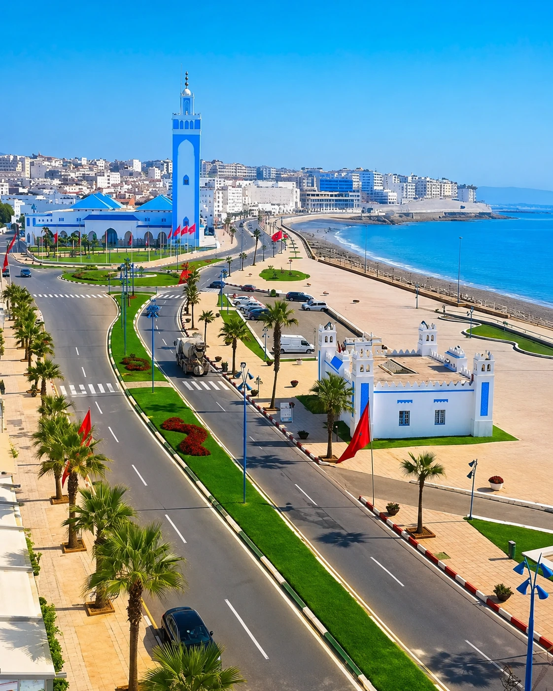
Fnideq seafront and mosque on Morocco's northern Mediterranean coast

Go deeper through the nearest city context

Fnideq, the coastal gateway to Belyounech & Jbel Musa

Fnideq gives Belyounech and Jbel Musa their clearest visitor base. It connects the mountain coast to shops, road orientation, Mediterranean beaches, Tetouan direction and the wider rhythm of Morocco's far north.

Use Fnideq to widen the context after the landscape itself: the visit becomes easier to understand as part of a north-coast sequence rather than a single isolated viewpoint.

Nearest city contextMediterranean coast orientation Belyounech road approachTetouan connection Strait landscape readingPractical north-coast base

Continue the journey

Continue from Belyounech into Morocco's northern coast.

Read the mountain slowly, follow the coastline with care, then connect Jbel Musa to Fnideq, Tetouan, the Rif and the wider Strait-facing map of Morocco.