
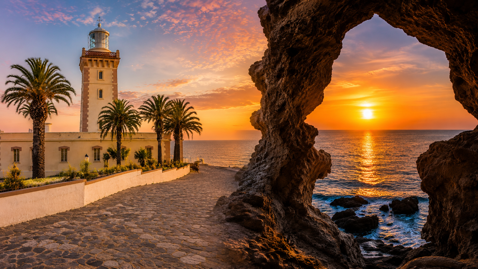
Cap Spartel lighthouse and the Caves of Hercules coastline at sunset near Tangier, Morocco

Visit / Place · Tangier coast · Atlantic and Strait edge

Cap Spartel & Caves of Hercules Where lighthouse, limestone and Atlantic light meet Tangier

Cap Spartel and the Caves of Hercules turn Tangier's western coast into a readable threshold: cliffs, lighthouse, cave opening, sea wind and the entrance to the Strait of Gibraltar.

Read the site as a pair. The cape gives the wide geography: sea, height, lighthouse and horizon. The caves bring the same coast down to human scale, where limestone, shadow and the Atlantic opening make the landscape feel close enough to touch.

Why Cap Spartel & the Caves matter

A coastal threshold before it is a viewpoint.

Cap Spartel matters because it makes Tangier's geography visible. West of the city, the coast rises into a headland that helps frame the Atlantic side of the Strait of Gibraltar. The experience is not only a panorama; it is a lesson in position, sea movement, maritime orientation and the way northern Morocco opens toward both ocean and strait.

The lighthouse gives this landscape a civic and navigational presence. Its vertical form turns the headland into a marker, reminding visitors that this coast has long been read by sailors as well as by travellers. The building is not merely a photo subject; it belongs to the practical history of seeing, warning, guiding and locating ships along a difficult edge.

The Caves of Hercules add another layer. Morocco's Ministry of Culture describes them as a protected site on the Cap Spartel massif, carved into natural limestone along the Atlantic coast and lit by an opening toward the ocean. That makes the cave valuable as geology, visitor experience and cultural memory at once.

The mythology is part of the atmosphere, but the strongest reading stays grounded. Hercules belongs to the old Mediterranean imagination around straits, pillars and heroic passage. The cave itself is more immediate: dark stone, damp air, rough surfaces and a sea-facing frame that makes the Atlantic feel suddenly architectural.

Together, cape and cave explain why this is one of Tangier's most legible short journeys. It moves from city to coast, from open horizon to enclosed rock, from maritime marker to natural opening. The visitor sees not a single attraction, but a compact coastal story with landscape, legend, light and restraint held in one place.

Core place facts are grounded in the Moroccan Ministry of Youth, Culture and Communication listing for the Caves of Hercules and the Cap Spartel Lighthouse site. Practical details such as prices, opening arrangements and exact transport times should be checked close to travel.
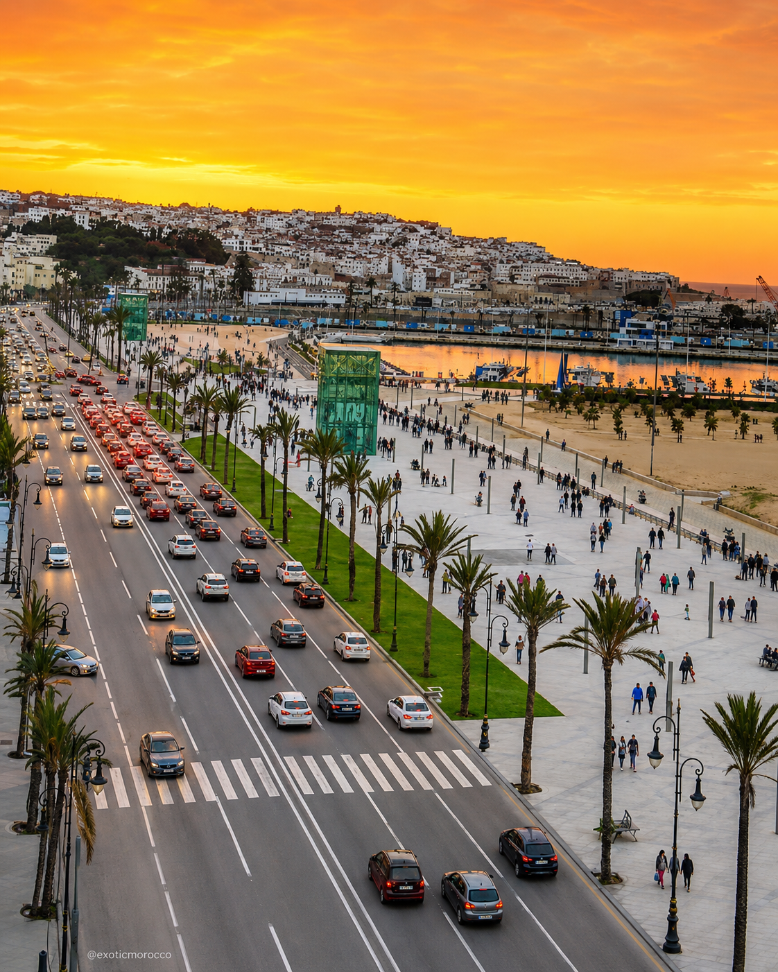
Tangier waterfront at sunset, the city base for visiting Cap Spartel and the Caves of Hercules

Map orientation

Use the map to read the relationship between Tangier, the cape, the cave site and the Atlantic edge before treating the visit as a simple photo stop.

Editorial reading

Its drama comes from geography, not exaggeration.

The cape is powerful because it organizes the horizon. From here, the coast does not feel flat or passive; it becomes a meeting of height, wind, sea traffic and Atlantic light. The lighthouse sharpens that reading by giving the headland a human marker without overpowering the landscape.

The cave asks for a different pace. Inside or near the opening, the view narrows. Rock replaces skyline, the sea becomes a framed surface, and the visitor understands why natural openings can carry myth without needing artificial drama. The place already has enough force.

Look for the contrast between exposure and enclosure. Cap Spartel is open air, distance and salt wind. The Caves of Hercules are shadow, texture and concentrated sound. Seeing both in one visit gives the coast rhythm: first the wide map, then the close reading.

Photography works best when it respects that rhythm. The lighthouse should not be isolated from the cape, and the cave should not be flattened into a single famous opening. Let stone, horizon, pedestrians, guardrails, paths and sea direction remain part of the visual truth.

A careful visitor also notices the modern pressure around famous places. Popular coastal sites can become crowded, rushed and over-photographed. The better experience is slower: arrive with curiosity, keep space for others, avoid risky edges, and let the place remain landscape rather than a stage.

The strongest memory is often the transition itself. Tangier's urban energy falls away, the Atlantic grows larger, the lighthouse appears, and then the cave pulls the same coast inward. That movement from city to cliff to stone is the real intelligence of the visit.

Historical and heritage orientation

Read the site through coast, navigation, limestone and legend.

Cap Spartel and the Caves of Hercules should be understood as a coastal heritage landscape rather than as two disconnected stops. The cape gives Tangier a maritime edge at the western approach to the Strait of Gibraltar, while the caves bring natural limestone, Atlantic erosion, visitor memory and myth into one concentrated place.

01Place type

Headland and cave site

This is a paired coastal place: a cape, a lighthouse setting and a cave complex close enough to be read as one Tangier coast experience.

02Maritime marker

Cap Spartel Lighthouse

The lighthouse belongs to Morocco's maritime heritage and gives the headland its clearest built marker: a vertical sign of navigation, distance and coastal orientation.

03Natural fabric

Limestone and ocean

The Caves of Hercules are described by Morocco's cultural authorities as natural limestone caves on the Atlantic coast, illuminated by a passage opening toward the ocean.

04Cultural memory

Hercules and the strait

The cave is tied to the Hercules legend in popular and classical imagination. Treat that mythology as part of the site's cultural atmosphere, not as a substitute for careful observation.

A visual bridge

Three readings between sea, stone and city

Before the place becomes a sunset image, read how each layer changes the scale of the visit. Cap Spartel opens the view outward; the lighthouse fixes the eye; the cave narrows the coast into rock, shadow and sound.

01

Horizon

The cape as orientation

Start with the headland. It explains why the site feels bigger than a viewpoint: the eye meets sea, sky, cliff, wind and the western approach to a major strait.

  • Read the horizon before taking close photos.
  • Notice how the lighthouse anchors the open view.
  • Keep the Atlantic edge in the frame.
02

Stone

The cave as a sea frame

The cave changes the visit from wide landscape to close texture. Limestone, shadow and the ocean opening make the coast feel sculpted rather than simply scenic.

  • Look for rough limestone surfaces and damp shade.
  • Let the sea opening act as a frame, not only a backdrop.
  • Move carefully where surfaces are uneven or busy.
03

Route

Tangier as the base

The visit makes most sense when connected back to Tangier: city energy, Atlantic road, cape, cave and return. That short route gives the place its human rhythm.

  • Use Tangier as the cultural and practical context.
  • Link the stop with the wider northern coast.
  • See the journey as city-to-landscape, not a detached excursion.

Quick orientation

Type of place

A coastal headland, lighthouse landscape and limestone cave site west of Tangier, best read through geography, sea light, natural stone and maritime orientation.

Region context

The site belongs to the Tangier coast in northern Morocco, where Atlantic light, Strait geography and city proximity create a compact but powerful visitor route.

Best for

Coastal views, lighthouse photography, cave atmosphere, sunset light, slow visual reading, Tangier day planning and a deeper sense of Morocco's northern maritime edge.

Closest city context

Tangier is the natural base: it gives the visit cultural depth, transport logic, onward city orientation and a strong frame for understanding the surrounding coast.

What visitors experience here

A coast that shifts from open horizon to enclosed stone.

The visit works through contrast. Cap Spartel begins with openness: sea wind, lighthouse, palms, cliff edge and broad sky. The Caves of Hercules then compress that same coast into shadow, limestone and a sea-facing opening that turns the Atlantic into a framed image.

Arrival

The road out of Tangier

The first change is spatial. Tangier's urban movement gives way to coastal air, wider views and the sense that the city is opening toward a different geography.

Lighthouse

A vertical point on the cape

The lighthouse gives the headland proportion. Its form helps the eye measure height, distance and maritime purpose against the larger scale of sea and sky.

Sea

Atlantic light and moving water

Light changes the place quickly. Clear weather can sharpen the horizon; late sun warms the stone; wind and tide alter the mood without needing staged drama.

Cave

Shadow, limestone and the opening

Inside the cave context, the view becomes concentrated. Rough surfaces, darker air and the ocean passage turn the coastline into an intimate visual chamber.

Pace

A short visit that deserves attention

The site is often visited quickly, but it rewards a slower eye. The cape, cave, paths and viewpoints each explain something different about the same coast.

Memory

Myth without losing reality

The Hercules name gives the place symbolic depth, yet the strongest impression remains physical: stone, water, wind, horizon and Tangier's nearness behind you.

Place details and orientation

Read Cap Spartel and the caves through six defining elements

No single feature explains the site. Its meaning comes from the relationship between headland, lighthouse, limestone, cave opening, Atlantic coast and Tangier route context.

1
Cap Spartel headland

The cape gives the visit its first scale: height, horizon, exposed air and the feeling of being on a coastal edge rather than inside the city.

2
Lighthouse marker

The lighthouse is the clearest built element, turning the cape into a navigational and photographic anchor without replacing the landscape itself.

3
Natural limestone

The caves are rooted in limestone rather than decoration. Their surfaces should be read as geology shaped by coast, time, humidity and human attention.

4
Ocean-facing opening

The famous sea opening matters because it frames the Atlantic from inside stone, compressing a huge horizon into a single readable view.

5
Atlantic edge

Paths, viewpoints and wave sound connect the cave and cape to the wider shore. Stay aware of wind, uneven ground and changing conditions near edges.

6
Tangier connection

The site is strongest when linked back to Tangier's port, medina, waterfront and northern coastal identity rather than treated as an isolated stop.

Coast, not scenery

The place asks for a wide eye and a careful step.

Begin with the cape. The lighthouse, open air and horizon tell you where you are before the cave begins to tell you what the coast is made of. This order matters because the cave is more meaningful when the visitor already understands the wider maritime setting.

Then move toward the limestone. The rock surface, darker interior, sea-facing opening and sound of water change the scale of the visit. What was previously open and panoramic becomes tactile, enclosed and almost architectural.

End by connecting both views. Cap Spartel gives distance; the Caves of Hercules give texture. Together they explain why Tangier's western coast is not only beautiful, but legible: a place where geography, legend and visitor movement can be read in one short journey.

Landscape and route intelligence

The coast teaches through exposure and enclosure.

Cap Spartel is an exposed reading of the coast. Its intelligence comes from position: the headland, lighthouse and open sea help visitors understand why this part of Morocco has always felt connected to movement, navigation and horizon.

The Caves of Hercules reverse that openness. Limestone gathers the visitor into a smaller space where the Atlantic is no longer a broad field but a framed presence. The contrast between cape and cave is what makes the place more memorable than either feature alone.

What to notice slowly

  • Start with the full coastal position before focusing on the cave opening.
  • Notice how the lighthouse gives scale to the cape and horizon.
  • Read limestone texture as natural material, not as a decorative surface.
  • Watch how light changes from open cape to darker cave interior.
  • Keep Tangier in mind as the cultural and practical base for the visit.
  • Respect barriers, edges, busy paths and any areas marked as closed or fragile.

Visual reading

Three visual languages to notice

Lighthouse as marker

The lighthouse turns the cape into a measured vertical sign. It belongs to navigation and distance, so photograph it with enough space around it to keep the maritime context alive.

Cave as frame

The cave opening makes the sea visible through stone. Its force comes from the contrast between rough limestone, interior shadow and bright Atlantic surface beyond.

Coast as threshold

The whole place sits between city and sea, openness and enclosure, fact and legend. That threshold quality is the site's real visual identity.

Visual atmosphere

Wind, stone and sunset discipline

From distance to detail

Start with the wide cape and lighthouse, then move closer to the cave. The shift from horizon to limestone helps the visitor understand the site as a sequence rather than a single snapshot.

From sky to stone

The strongest colour is natural: orange light on sea, warm stone, pale walls, blue shadow and Atlantic reflection. Avoid reading the place through heavy filters; the real palette is already rich.

From photo to memory

The lasting memory is not only the famous cave opening. It is the road from Tangier, the wind at the cape, the lighthouse against the sky and the moment the ocean appears through rock.

Nearby places and onward links

Connect the cape and caves to the wider northern Morocco map

Cap Spartel and the Caves of Hercules belong naturally inside a Tangier journey, then open toward northern Morocco's coastal routes, Atlantic city links and careful place-based travel planning.

Tangier

The closest and strongest city context. Use Tangier to connect the visit with port history, medina life, waterfront movement and northern Morocco's meeting of cultures.

Open Tangier city guide

Northern Morocco & Rif

The broader regional frame for Tangier, the Strait coast, mountain routes, blue cities, Mediterranean edges and northern cultural geography.

Explore the region

Atlantic Coast & Historic Ports

Use this region to extend the reading from Tangier's Atlantic edge toward Morocco's wider coastal cities, ports, fortifications and ocean-facing routes.

Explore Atlantic routes

Architecture & Heritage

The lighthouse, cave and cultural memory belong to a wider Moroccan heritage reading where material, route and place identity matter more than surface spectacle.

Read the theme

Visit Morocco places

Continue through caves, capes, kasbahs, valleys, monuments, lagoons and natural landmarks across the Visit section.

Browse Visit places

Plan your journey

Treat the site as part of a Tangier coastal route with weather, light, timing and respectful visitor behaviour considered before you go.

Plan your journey

How to visit respectfully

Good behaviour keeps the coast readable.

Cap Spartel and the Caves of Hercules are popular because they are accessible, dramatic and easy to photograph. That popularity makes restraint important. Move patiently in narrow or crowded areas, avoid blocking the cave opening for others, and give the coast enough time to be understood beyond a single image.

Respect also means taking the physical setting seriously. Limestone, cave floors, coastal paths and cliff viewpoints can be uneven, damp, busy or exposed to wind. Follow local guidance, stay behind barriers, avoid risky poses near edges and leave no litter on the shore or paths.

  • Ask clearly before photographing identifiable people, staff, guides or private moments.
  • Stay on appropriate routes around the cave, lighthouse area and coastal viewpoints.
  • Do not scratch rock, climb fragile surfaces or force access into closed areas.
  • Carry water and sun protection, especially when the visit extends along the coast.
  • Check current access, local guidance and practical arrangements close to travel.

A strong first visit

Begin at the cape with the broadest view. Let the lighthouse, horizon and sea direction establish the geography before moving toward the caves. This order helps the visit feel coherent: the landscape is understood first, the detail second.

At the cave site, slow down. Notice the darker air, the roughness of limestone, the sound of water and the way the ocean opening changes as people move around it. The famous view is strongest when it is not rushed.

Use Tangier as more than a departure point. Before or after the coast, the city adds the human context: medina streets, port identity, waterfront movement and the long history of looking across water from northern Morocco.

Plan with flexibility. Weather, wind, crowds and light can change the feeling of the site. A careful visitor accepts those changes rather than forcing the place into a fixed expectation.

  • Start outside, where cape, lighthouse and horizon are easiest to read together.
  • Move inward toward the cave after the wider geography is clear.
  • Give others space at the sea opening and main photo points.
  • Connect the visit back to Tangier instead of treating it as a detached stop.
  • Let weather and light shape the pace of the visit.

Careful planning note: opening hours, prices, exact access routes and transport times can change. Verify practical arrangements locally before travelling.

Tangier waterfront at sunset, the city gateway context for Cap Spartel and the Caves of Hercules

Go deeper through the nearest city context

Tangier - the city gateway to Cap Spartel and the Caves of Hercules

Cap Spartel and the Caves of Hercules belong naturally inside a Tangier journey. The city gives the coast its strongest context: port history, medina life, Atlantic road, Strait imagination and the modern waterfront rhythm that visitors feel before leaving for the cape.

Use Tangier to widen the visit after the cliffs and caves. The place becomes richer when it is connected to the city behind it: a northern Moroccan base where sea routes, cultural layers, language, architecture and everyday movement meet.

Tangier city orientationAtlantic coastal route Strait of Gibraltar contextLighthouse and cave reading Medina and waterfront rhythmPractical travel structure

Continue the journey

Continue from Cap Spartel into Tangier and northern Morocco.

Read the cape and caves slowly, then connect them to Tangier, the Strait, Atlantic light, northern routes and the wider Exotic Morocco map.