
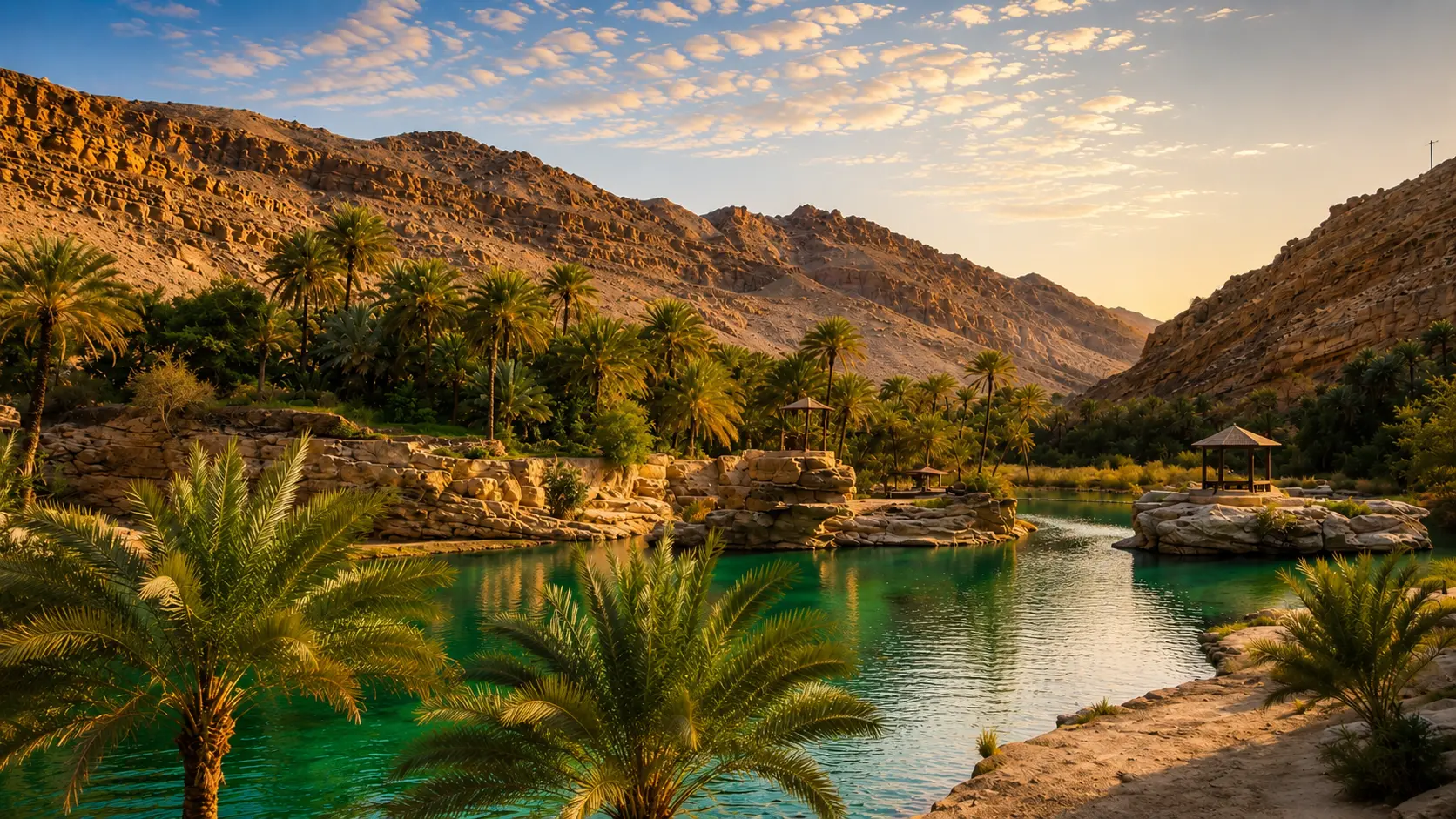
Palm oasis, water and desert mountains in the Draa Valley of southern Morocco

Visit / Place · Southern Morocco · Drâa oasis corridor

Draa Valley A great southern oasis corridor of palms, riverbeds and earthen villages

The Draa Valley is not a single viewpoint. It is a long desert-edge landscape where water, date palms, ksour, kasbahs and route memory shape the way southern Morocco is read.

Begin with the line of green against mineral ground. The valley makes sense when the river corridor, palm groves, villages, dry hills and southern roads are seen together, before any one stop becomes the whole story.

Why Draa Valley matters

An oasis corridor before it is a postcard.

The Draa Valley matters because it makes the fragile logic of southern Morocco visible at landscape scale. A visitor can see, almost immediately, how water creates settlement, how palms soften an arid edge, and how earthen villages hold their colour against stone, dust and open sky.

This is not the beauty of a single monument. It is a corridor of relationships: riverbed and irrigation, date palms and gardens, ksour and kasbahs, small roads and desert approaches. The valley asks to be read as a human geography shaped by scarcity, adaptation and careful use of place.

Morocco's official tourism material places the Drâa palm groves, Agdz, Zagora, Tinfou, Chigaga and the Draa/Dades route family inside the wider Ouarzazate-Zagora-Tinghir travel context. That framing is useful because the valley is best understood as part of a southern route system rather than as one isolated stop.

The most powerful contrast is simple and deep: green life pressed between dry mountains and desert-edge ground. Date palms, cultivated plots and adobe-coloured settlements do not decorate the valley; they reveal how people have organised shade, food, movement and shelter around water.

For visitors, the reward is slower attention. The Draa Valley becomes richer when the eye notices channels, terraces, palm density, village edges, repaired earth, empty river sections and the way light changes from soft oasis shade to hard open exposure within a short distance.

Core orientation is grounded in Morocco's official tourism pages for Ouarzazate-Zagora-Tinghir nature and the Road to the Kasbahs. Practical access, road conditions and local opening arrangements should be checked close to travel.
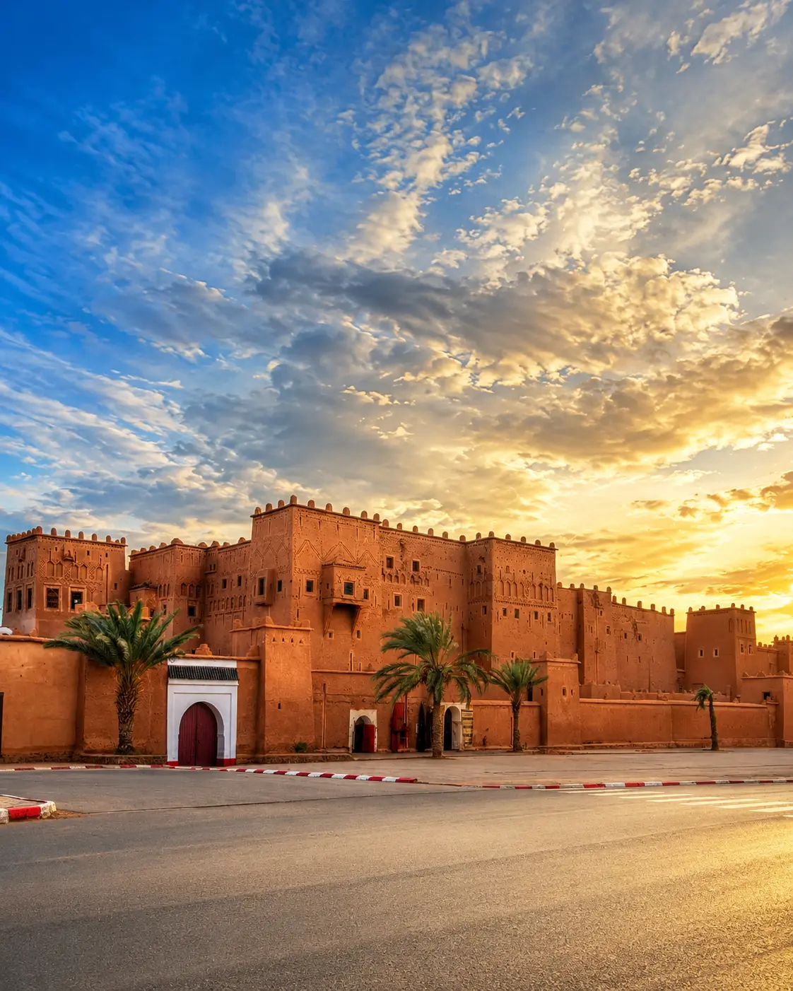
Ouarzazate earthen kasbah at sunset, the northern gateway context for Draa Valley

Map orientation

Use the map to understand the valley as a long corridor, not a pin. Read the relationship between Ouarzazate, Agdz, Zagora, palm groves and the routes that continue toward desert-edge landscapes.

Editorial reading

Its drama is the line between green and stone.

The first impression is often the palm belt: a living green line inside a dry geography. That contrast is beautiful, but it is also practical. Shade, cultivation, settlement and movement all gather around the same water logic.

Look beyond the palms and the valley becomes more precise. Earthen walls mark village edges. Gardens sit low and protected. Hills keep their mineral colour. Roads follow the easiest openings through the landscape. Every element explains another element.

The Draa Valley is also a lesson in proportion. From a distance, the palmeraie can look like one continuous mass. Up close, it breaks into paths, plots, channels, walls, thresholds and small decisions that make oasis life legible.

A strong visit keeps that double scale alive: wide enough to see the valley as a corridor, close enough to notice how people, palms, water and earth meet at the edge of the Sahara.

Historical and heritage orientation

Read the valley through water, settlement and route memory.

Draa Valley is best approached as an oasis landscape rather than a single attraction. Its importance comes from the way the Drâa watercourse, palm groves, earthen settlement forms and southern routes meet in a demanding climate. The visitor is reading a system of adaptation, not only a sequence of views.

01Place type

Oasis valley corridor

The valley is a broad travel and settlement corridor where palms, gardens, villages and dry land sit in direct relationship. It should be understood at landscape scale.

02Water logic

River, channels and cultivation

The Drâa context explains why green areas appear so sharply against mineral surroundings. Water distribution, seasonal conditions and irrigation shape what can grow and where people settle.

03Built form

Ksour and kasbah landscapes

Fortified earthen villages, kasbah forms and compact settlement edges belong naturally to this oasis geography. They connect protection, shade, storage, family life and route position.

04Route context

Agdz, Zagora and the desert edge

The valley links northern access from the Ouarzazate side with oasis towns, palm groves and onward southern routes. It is strongest when read as movement through changing terrain.

A visual bridge

Three readings between water, palms and stone

The Draa Valley becomes memorable when visitors stop treating each view as separate. Water explains palms; palms explain shade and settlement; settlement explains the earthen colour and the rhythm of roads through the south.

01

Water

The hidden structure

Even where the visible riverbed feels quiet or dry, water remains the valley's organizing idea. It determines the green line, the agricultural plots, the shade and the places where villages gather.

  • Look for channels, banks and garden edges.
  • Notice where palms thicken or thin.
  • Read dryness and greenery as one system.
02

Palms

Shade as architecture

The palmeraie is not background decoration. It changes temperature, light, walking rhythm and visual depth, creating a softer human scale inside a landscape that can otherwise feel exposed.

  • Move from open light into palm shade.
  • Watch how gardens sit below village edges.
  • Give agricultural spaces real respect.
03

Earth

Villages in the colour of place

Earthen buildings feel powerful here because they belong to the valley's materials and light. Their colour does not compete with the landscape; it makes settlement look rooted in it.

  • Read walls against palms and dry hills.
  • Notice repaired surfaces and thresholds.
  • Keep private homes out of casual photography.

Quick orientation

Type of place

A southern Moroccan oasis valley and route corridor, best understood through water, palm groves, earthen villages and desert-edge landscape transitions.

Landscape context

The valley belongs to the wider Ouarzazate-Zagora-Tinghir southern context, where green oases, dry mountains, kasbah routes and desert approaches meet.

Best for

Oasis landscapes, palm-grove walking, careful photography, kasbah-route context, village-edge observation, slow road travel and visual reading of water in arid terrain.

Closest city context

Ouarzazate is the clearest northern gateway, while Zagora gives a strong valley-side orientation for visitors moving deeper into the Drâa corridor.

What visitors experience here

The landscape changes by layers, not by stops.

Draa Valley works slowly. First comes the wide contrast of palms and dry hills. Then the villages appear, the road bends, the light hardens, the riverbed opens, and the valley begins to reveal how settlement and landscape depend on each other.

Arrival

The green line from above

From higher ground or a roadside view, the palmeraie reads as a continuous band of life. That first wide view gives the valley its grammar: green, earth, stone and sky.

Light

Soft shade, hard exposure

The visual atmosphere changes quickly. Palm shade can feel cool and layered, while nearby open ground returns the visitor to bright southern exposure and sharper mineral colour.

Water

The riverbed as memory

The Drâa context is not always a full, photogenic river scene. Sometimes the bed, banks, channels and vegetation tell the more honest story of seasonal water and careful use.

Villages

Earthen edges and rooftops

Villages and kasbah forms appear in colours close to the ground around them. Their beauty comes from belonging: walls, roofs, lanes and towers shaped by material, heat and protection.

Movement

A road that asks for pauses

The valley should not be rushed as scenery seen only through glass. Short stops, careful walks and patient viewpoints reveal more than a fast drive between named destinations.

Desert edge

Where green begins to thin

Moving south, the balance shifts. Palms, villages and cultivated spaces meet increasingly open terrain, making the transition toward desert landscapes visible rather than sudden.

Place details and orientation

Read Draa Valley through six defining elements

No single village, viewpoint or palm grove explains the valley. Its meaning comes from the relationship between water, cultivation, settlement, route, material and the exposed landscapes around them.

1
Drâa watercourse

The watercourse gives the valley its structure, even when visible water is limited. It explains the green corridor and the settlement pattern around it.

2
Palmeraies

Date palms create shade, depth and agricultural identity. They also make the contrast between oasis and dry ground visually unmistakable.

3
Ksour and kasbahs

Earthen fortified settlement forms belong to the valley's route and oasis logic. They should be read as community and protection systems, not only as photogenic shapes.

4
Village edges

The meeting point between homes, gardens, lanes and palms is one of the valley's richest visual lessons. This is where landscape becomes daily life.

5
Agdz and Zagora context

Agdz and Zagora help frame the corridor for visitors, giving practical orientation without reducing the valley to only two named points.

6
Southern route transition

The valley gradually opens toward desert-edge landscapes. That transition is part of the experience and should be read with patience.

Oasis, not scenery

The place asks for a careful eye.

Stand back first. The strongest lesson is spatial: a green line held inside dry land, with palms, villages and roads arranged around the possibility of water. That wide reading prevents the visit from becoming only a collection of attractive stops.

Then move closer. The valley becomes human through paths, channels, garden walls, shaded lanes, rooftops and thresholds. These details show how oasis life is organised in small, practical layers.

Finally, return to the landscape. The dry hills and open southern light are not empty background. They explain why the green corridor feels so intense, why shade matters, and why visitors should move with restraint.

Landscape and material intelligence

Water makes the composition legible.

The Draa Valley's beauty is not separate from its practical intelligence. Palms grow where water and cultivation allow them. Earthen settlements gather where shade, route, protection and land use make sense. Dry hills remain visually close, reminding the visitor how exact the oasis line is.

This is why the valley should be read slowly. A clean photograph may capture the contrast, but the real understanding comes from seeing the system: water, trees, fields, villages, road, mountain and desert edge all working in relation.

What to notice slowly

  • Look for the boundary where palms end and mineral ground begins.
  • Notice how village colour stays close to the surrounding earth.
  • Read irrigation channels, banks and garden edges as part of the view.
  • Move carefully near cultivated plots and avoid stepping into private agricultural space.
  • Watch how light changes between palm shade, rooftops and open road.
  • Treat older earthen walls and fragile edges as vulnerable material, not as climbing surfaces.

Visual reading

Three landscape languages to notice

Green against mineral ground

The valley's most immediate language is contrast. Palms and gardens appear almost drawn into the dry terrain, revealing how sharply life concentrates around water.

Built earth and palm shade

Earthen buildings and palms belong visually together. One gives mass, enclosure and colour; the other gives shade, rhythm and vertical softness.

Distance and settlement scale

From far away, the valley reads as a broad oasis corridor. Up close, the same landscape becomes paths, thresholds, channels, walls and human-scale movement.

Visual atmosphere

Light, palms and quiet transitions

From palm shade to open light

The best visual rhythm comes from moving between shade and exposure. Under palms, colour softens and details gather. Outside the oasis line, the same light becomes brighter, drier and more architectural.

From riverbed to route

The valley is shaped by a watercourse, but the visitor often experiences it through road, pauses and viewpoints. Read the riverbed, channels and vegetation together with the direction of travel.

From image to memory

A beautiful frame may begin with palms and mountains, but the deeper memory is the transition: the sound of wind in leaves, the dry colour of walls, the pause at a village edge and the awareness that water gives the place its form.

Nearby places and onward links

Connect the valley to the wider southern Morocco map

Draa Valley belongs naturally inside a southern itinerary. Ouarzazate gives the cleanest gateway context, while the wider region opens toward oases, kasbah landscapes, desert approaches and careful route planning.

Ouarzazate

The strongest northern city context for Draa Valley. Use it to frame the move from High Atlas approaches into oasis routes, kasbah landscapes and southern travel structure.

Open Ouarzazate city guide

Southern Morocco, Oases & Sahara

The regional home for palm-grove routes, desert-edge landscapes, earthen architecture and the wider south-facing journey.

Explore the region

Architecture & Heritage

The valley gives a strong reading of earthen building, settlement edges, kasbah landscapes and the relationship between material and place.

Read the theme

Visit Morocco places

Continue through valleys, waterfalls, lagoons, caves, monuments, kasbahs and natural heritage places beyond the city guides.

Browse Visit places

Plan your journey

Treat Draa Valley as a route landscape, not a quick detour. Plan time for viewpoints, palm-grove stops, village respect and changing light.

Plan your journey

Stories from Morocco

Use the Stories section for richer cultural reading around place, memory, water, landscapes and the human rhythm behind visual heritage.

Read stories

How to visit respectfully

Good behaviour protects the valley.

Draa Valley is lived landscape, not an empty backdrop. Move gently through villages and palm groves, keep private homes private, ask before photographing people, and avoid treating agricultural paths or courtyards as public stages.

Respect also means caring for fragile materials and scarce resources. Earthen walls can be vulnerable, irrigation channels are practical infrastructure, and litter or careless driving has a sharper impact in oasis environments. A slower visitor sees more and disturbs less.

  • Ask clearly before photographing local people, workers, guides, shops or private interiors.
  • Stay on appropriate paths and avoid stepping into cultivated plots or channels.
  • Do not climb on old walls, rooftops, ruins or fragile earthen edges.
  • Carry water, protect yourself from exposed light and avoid rushing stops in heat.
  • Check current road, weather, access and local guidance close to travel.

A strong first visit

Begin with a wide view if possible. Seeing the palm corridor from above or from a clear roadside perspective gives the visit its structure: green valley floor, earthen settlement, dry hills and route direction become one readable composition.

Then choose fewer stops and give them more attention. Walk slowly near palm groves where access is appropriate, pause at village edges without blocking movement, and notice how gardens, walls, rooftops and channels sit together.

Use Ouarzazate or Zagora context to organise the journey, but let the valley itself set the pace. It is stronger as a sequence of observations than as a checklist of quick photographs.

Before travelling, verify current local conditions. Rain, road works, heat, seasonal water levels and access arrangements can change the experience, especially in valley and desert-edge landscapes.

  • Start wide, so the oasis corridor is understood before the details.
  • Stop with care, leaving room for local traffic, work and village life.
  • Walk only where access is appropriate and visible paths make sense.
  • Use shade and timing intelligently; the exposed light is part of the place.
  • Finish by connecting the valley back to Ouarzazate, Zagora and the southern region.

Careful planning note: exact travel times, road conditions, access rules and local services can change. Confirm practical details locally before travelling.

Ouarzazate earthen kasbah at sunset used as the Draa Valley guide cover

Go deeper through the nearest city context

Ouarzazate — the northern gateway to Draa Valley

Draa Valley connects naturally with a wider Ouarzazate journey. From that city context, visitors can read the south more clearly: High Atlas approaches, kasbah routes, oasis landscapes, desert-edge roads and the shift from built earth to open terrain.

Use Ouarzazate to structure the beginning of the route, then let the valley widen the story through Agdz, Zagora, palm groves, villages and the slow visual intelligence of water in the south.

Southern route contextOuarzazate city orientation Palm-grove landscapesKasbah and village reading Practical travel structureDesert-edge transitions

Continue the journey

Continue from Draa Valley into southern Morocco.

Read the oasis corridor slowly, then connect it to Ouarzazate, Zagora, palm-grove routes, earthen villages and the wider southern map of Morocco.