
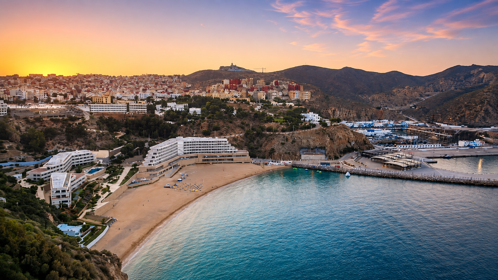
Quemado Beach below Al Hoceima at sunset, with the city, cliffs, port and Mediterranean water

Visit / Place · Al Hoceima · Mediterranean coast

Quemado Beach Al Hoceima's city bay of clear water, cliffs and sunset light

Quemado Beach is the central strand below Al Hoceima: a compact Mediterranean bay where city, harbour, cliff and water meet in one bright coastal view.

Begin from above before stepping down to the sand. The beach is easiest to understand when the full bay is visible first: the curve of water, the cliff-backed city, the harbour edge and the evening light that softens the Rif coast.

Why Quemado Beach matters

A city beach before it is a view.

Quemado Beach matters because it gives Al Hoceima a clear meeting point between the city and the Mediterranean. It is not a remote wild cove or a decorative strip of sand. It sits below the urban edge, held by cliffs and watched by the surrounding hillside, so the beach always feels connected to daily life as well as to travel.

Official Moroccan tourism material places Quemado among the beaches of Al Hoceima and frames the city through its blue Mediterranean waters, bay, port and surrounding coastal scenery. That context is important: the beach is strongest when read as part of Al Hoceima's waterfront geography, not as an isolated postcard detached from the city above it.

The visual power comes from compression. Sand, water, hotels, harbour structures, roads, city blocks and rough brown slopes sit close together. The bay does not need a long narrative to make sense; its meaning is in the way urban Morocco, Rif relief and clear sea occupy the same small frame.

For visitors, Quemado is useful because it makes orientation immediate. From one viewpoint, you can understand where Al Hoceima sits, how the city drops toward the water, how the port holds one side of the bay, and why this coast feels different from Morocco's longer Atlantic beaches.

Its beauty is therefore public and spatial. The best visit respects that public character: families, swimmers, fishers, hotel guests, walkers and photographers may all share the same compact shore. The beach rewards a careful eye, but it also asks for ordinary courtesy.

Core orientation is grounded in the official Visit Morocco Al Hoceima guide and its Al Hoceima beach overview. Seasonal services, swimming conditions and local access should be checked close to travel.
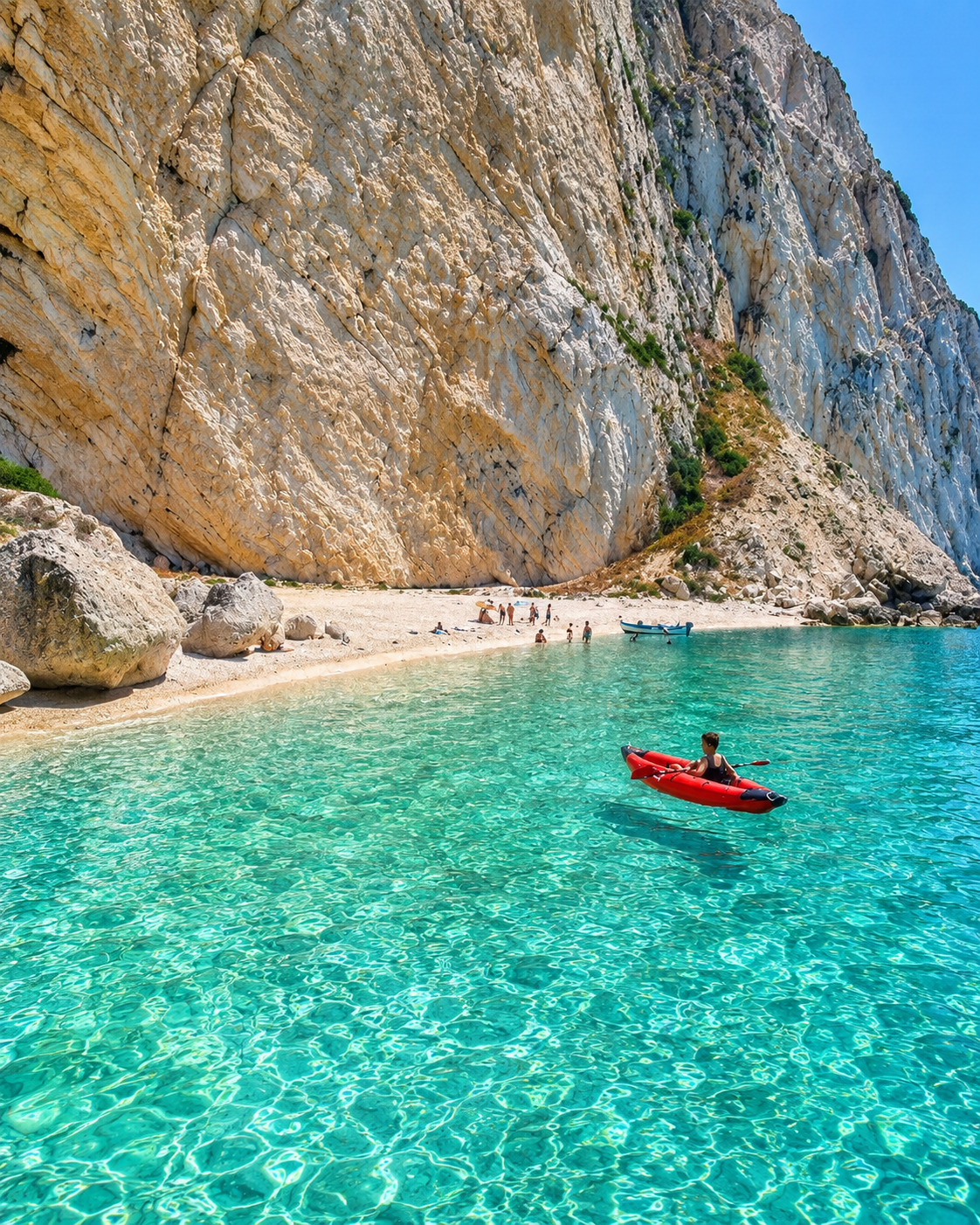
Clear turquoise water and pale cliffs on the Al Hoceima coast near Quemado Beach

Map orientation

Use the map to place the beach below Al Hoceima, close to the waterfront, port area and cliff-backed city edge.

Editorial reading

Its drama comes from proximity.

Quemado Beach is not dramatic because it is hidden. It is dramatic because everything is close: the city above, the slope behind it, the sand below, the harbour at the side and the Mediterranean opening outward from the bay.

That closeness changes the way the place should be seen. The beach is both leisure space and orientation point. It tells you how Al Hoceima is built into the Rif coast, how the city looks toward the sea, and how a small bay can carry a strong sense of place without needing monumental architecture.

The water is often remembered first, especially when it turns turquoise near the shore. But the more complete image includes the harder edges: rock, concrete, harbour lines, hotel terraces, road curves and the steep ground that makes the beach feel tucked below the city.

Look also at scale. From above, people on the sand become small and the whole bay reads as a shape. From the shoreline, the cliffs and buildings feel taller, and the sea becomes the main space. The same beach therefore changes character with only a short change in height.

The strongest light is usually a patient light rather than a harsh one. Sunset gives the city a warmer outline, separates the dark slopes from the water and makes the beach read as part of a wider coastal theatre. It is beautiful, but it is still an everyday public place.

A careful visit keeps that balance. Enjoy the view, swim only with attention to present conditions, give space to families and local movement, and let the place remain a shared waterfront rather than a backdrop for hurried pictures.

Historical and coastal orientation

Read the beach through city, bay and Rif coastline.

Quemado Beach is best understood as a central coastal place within Al Hoceima rather than as a standalone resort image. Its character comes from the city's cliff-top position, the Mediterranean bay, the nearby port and the wider Rif shoreline of coves, rocky edges and blue water.

01Place type

Urban Mediterranean beach

Quemado is a beach within the Al Hoceima city context. Its identity is shaped by easy urban access, shared public use and a bay setting below the built waterfront.

02Landscape

Cliff-backed bay

The beach sits in a compact coastal form where pale sand, clear water and steep surrounding land are read together. The view from above is part of the experience.

03City context

Al Hoceima waterfront

The nearby port and urban hillside keep the beach connected to working and residential rhythms. It is a visitor place, but not separated from the city.

04Care

A shared shore

Because the beach is compact and popular, respectful use matters: clean sand, quiet behaviour, careful swimming judgment and privacy around other visitors all protect the experience.

A visual bridge

Three readings between water, cliff and city

Before Quemado Beach becomes a sunset photograph, it is a precise meeting of forms. These three readings help visitors slow down and understand why the bay feels intimate from the sand and expansive from above.

01

Water

The bay as a lens

The water gives the beach its first attraction, but it also acts like a lens for the city. The curve of the bay reflects sky, cliff and buildings, turning a small urban shore into a wider coastal scene.

  • Start with the full curve of the shoreline.
  • Notice how water colour changes with depth and light.
  • Read the sea together with the harbour edge.
02

Cliff

The city above the sand

The cliff and hillside keep the beach visually anchored. They explain why Al Hoceima feels suspended between mountain and sea, and why the best first impression often comes from looking down before walking down.

  • Use height to understand the whole bay.
  • Look for the meeting of built edge and rough slope.
  • Keep the Rif coastline in the background of the view.
03

Looking

Distance before detail

The strongest reading begins from a wide view, then moves toward sand, waterline, rocks and everyday beach rhythm. The details become richer once the whole coastal setting is clear.

  • Read the bay first as a complete shape.
  • Move slowly from overlook to shoreline.
  • Let sunset light clarify the city and cliffs.

Quick orientation

Type of place

A central Mediterranean beach in Al Hoceima, best understood as a compact city bay rather than a remote coastal hideaway.

Landscape context

The beach sits below the urban edge of Al Hoceima, framed by cliffs, harbour structures and the blue water of Morocco's northern coast.

Best for

Clear-water views, beach time, sunset photography, city-and-sea orientation, gentle walking and understanding Al Hoceima's coastal shape.

Closest city context

Al Hoceima is the essential guide context: the beach belongs to the city, its port, its viewpoints and the wider Rif Mediterranean shoreline.

What visitors experience here

A beach that changes with height, light and season.

Quemado Beach works in shifts. From above, it is a shaped bay below a city. From the sand, it becomes water, texture, voices, umbrellas, harbour edges and cliffs. In the evening, the same place softens into warm light and long reflections across the Mediterranean.

Arrival

The overlook first

The strongest arrival is visual. Seeing the beach from above helps the curve of sand, port side, city slope and open water settle into one clear mental map before you reach the shore.

Water

Clear Mediterranean colour

The bay is known for bright blue and turquoise water, though clarity always depends on light, weather and local conditions. Look at the shallows where sand and rock change the colour in small bands.

Movement

A compact walking rhythm

This is not a beach for endless wandering. Its rhythm is compact: descend, pause, cross the sand, follow the waterline, then look back toward the city and cliffs that hold the bay.

Texture

Sand, rock and harbour edge

The beach is soft in the centre, harder at the edges. Rocks, built waterfront lines and harbour structures give the scene definition and keep the image from becoming a generic resort view.

Light

Evening over Al Hoceima

Late light is especially expressive here because it touches the city, cliffs and sea at once. The view becomes warmer without losing the blue quality that defines the bay.

Pace

Public beach life

Quemado can feel lively, especially in warm seasons. The best visit accepts that shared rhythm: families, swimmers, walkers and photographers all belong to the same compact coastal space.

Place details and orientation

Read Quemado Beach through six defining elements

No single feature explains the beach. Its character comes from the relationship between the bay, cliff, city, harbour edge, water clarity and the changing light of the Rif coast.

1
The sand arc

The curve of the shore gives the beach its intimate scale and makes the whole bay easy to read from above.

2
The cliff frame

Steep surrounding land gives Quemado its sense of enclosure and separates the beach from flatter coastal resorts.

3
The city overlook

Al Hoceima rises behind the beach, so the view always carries urban presence as well as coastal beauty.

4
The harbour side

The port and waterfront structures mark one edge of the scene and connect leisure space with the working sea.

5
The waterline

Colour and clarity shift with weather, light and movement, making the shallow edge one of the best places to look slowly.

6
The sunset view

Evening light links city blocks, slopes, port and sea, giving the bay its strongest photographic and emotional register.

Bay, not backdrop

The place asks for a careful eye.

Stand above the beach first. The full form is the lesson: a shore held between city and water, cliffs and port, everyday movement and open Mediterranean horizon. That wide view prevents the beach from becoming only sand and sea.

Then move closer. The waterline, umbrellas, footsteps, rock edges and harbour sounds bring the place to human scale. Quemado is small enough to read in detail, but layered enough to reward more than a quick photograph.

Look back from the shore toward Al Hoceima. The city is not behind the experience; it is part of it. The beach helps explain the city, and the city gives the beach its distinctive Moroccan Mediterranean context.

Landscape and coastal intelligence

The bay is shaped by closeness.

Quemado's intelligence is spatial rather than architectural. The beach works because the city, cliff, harbour and sea are compressed into a readable coastal amphitheatre. That proximity gives the bay its drama, but it also means visitors share a limited public space.

The place should not be sold as untouched wilderness. Its value is different: it is a clear, urban Mediterranean beach where Al Hoceima's relationship with the Rif coast can be understood in one glance, then felt more slowly from the sand.

What to notice slowly

  • Look at the whole bay before focusing on water colour or beach activity.
  • Notice how the cliff and city change the scale of the shoreline.
  • Read the port edge as part of the scene, not as visual interruption.
  • Watch how the water changes from shallow turquoise to deeper blue.
  • Use late light to understand the relationship between city, slope and sea.
  • Respect the compactness of the beach by leaving room for other visitors.

Visual reading

Three coastal languages to notice

City and shore

Quemado speaks first through the relationship between Al Hoceima and the water. The beach is a threshold: not fully urban, not fully detached from the city, but a bright public edge between both.

Cliff and bay

The cliffs and slopes give the beach vertical drama. They make the bay feel protected from some angles and theatrical from others, especially when seen from above.

Water and use

The beauty of the water belongs beside everyday use. Swimming, walking, family time, hotel terraces and harbour movement all form part of the same visible coastal rhythm.

Visual atmosphere

Light, water and compact transitions

From height to shoreline

Begin with the overhead view, where the bay becomes a clean shape. Then descend toward the sand, where the scene changes into water movement, beach texture, human sound and the shadow of the cliffs.

From blue to mineral

The most memorable contrast is between clear Mediterranean colour and the dry mineral tones around it. The water feels brighter because the cliffs, harbour edge and city slope hold it in a firm frame.

From photo to memory

The image is immediate, but the better memory comes from the sequence: first the bay from above, then the waterline, then the city behind you, then the sunset joining everything into one calm coastal register.

Nearby places and onward links

Connect Quemado Beach to the wider Al Hoceima coast

Quemado belongs to an Al Hoceima journey. Use the city to frame the beach, then widen the map toward Rif coastline, national-park landscapes, regional orientation and practical planning.

Al Hoceima

The essential city context for Quemado Beach: waterfront viewpoints, port rhythm, neighbourhood scale and a stronger reading of the bay.

Open Al Hoceima city guide

Al Hoceima National Park

The wider protected coastal context west of the city, useful for understanding Rif cliffs, coves, walking landscapes and Mediterranean relief beyond the urban bay.

Explore the national park

Northern Morocco & Rif

The regional frame for mountains, Mediterranean shorelines, blue towns, port cities and the rugged coastal character around Al Hoceima.

Explore the region

Visit Morocco places

Continue through beaches, coves, lagoons, national parks, heritage sites, mountain landscapes and coastal routes beyond the city guides.

Browse Visit places

Plan your journey

Treat Quemado as an orientation point in Al Hoceima, then plan onward movement with attention to season, road rhythm, weather and coastal distances.

Plan your journey

Stories from Morocco

Use the Stories section for slower reading around Moroccan places, public life, landscapes, memory and the ways travel images are shaped.

Read stories

How to visit respectfully

Good beach behaviour protects the experience.

Quemado is a compact public beach, so respect begins with space. Keep paths, steps and waterfront access clear, avoid crowding other groups, lower noise when the beach is busy, and treat the sand and waterline as shared places rather than private scenery.

Photography needs the same care. Wide views of the bay are easy, but close photos can include families, swimmers and workers who did not agree to become part of a travel image. Ask when people are recognisable, and step back when the scene feels private.

  • Check current sea conditions locally before swimming, especially after wind or rough weather.
  • Keep the beach clean and carry litter away when bins are full or unavailable.
  • Give space to families, swimmers, fishers, staff and people using the waterfront for daily movement.
  • Use reef-safe, water-conscious habits and avoid leaving plastic or cigarette waste in the sand.
  • Verify seasonal facilities, access and beach services close to travel rather than relying on old information.

A strong first visit

Begin from a higher viewpoint so the full bay is visible. This first view gives the visit its structure: city above, beach below, harbour to the side, Mediterranean water ahead and Rif slopes framing the scene.

Move down slowly rather than rushing straight into the water. The descent helps you understand why Quemado is so tied to Al Hoceima's shape. By the time you reach the sand, the beach already has a setting and a story.

On the shore, keep the rhythm simple. Walk the waterline, notice where sand gives way to rock or built edge, watch the changing colour of the shallows, and save time for evening light if conditions allow.

Afterward, reconnect the beach to the city. A meal, port walk, viewpoint or city guide gives Quemado more meaning than treating it as a single beach stop detached from Al Hoceima.

  • Start above the beach, where the city-bay relationship is clearest.
  • Descend with attention to steps, paths and other people using the same access.
  • Read the harbour edge and cliffs as part of the place, not background noise.
  • Leave time for late light, when the beach and city become easier to photograph respectfully.
  • Finish by connecting the bay back to Al Hoceima and the wider Rif coast.

Careful planning note: beach services, crowds, sea conditions and access details can change by season and day. Check locally before travelling or swimming.

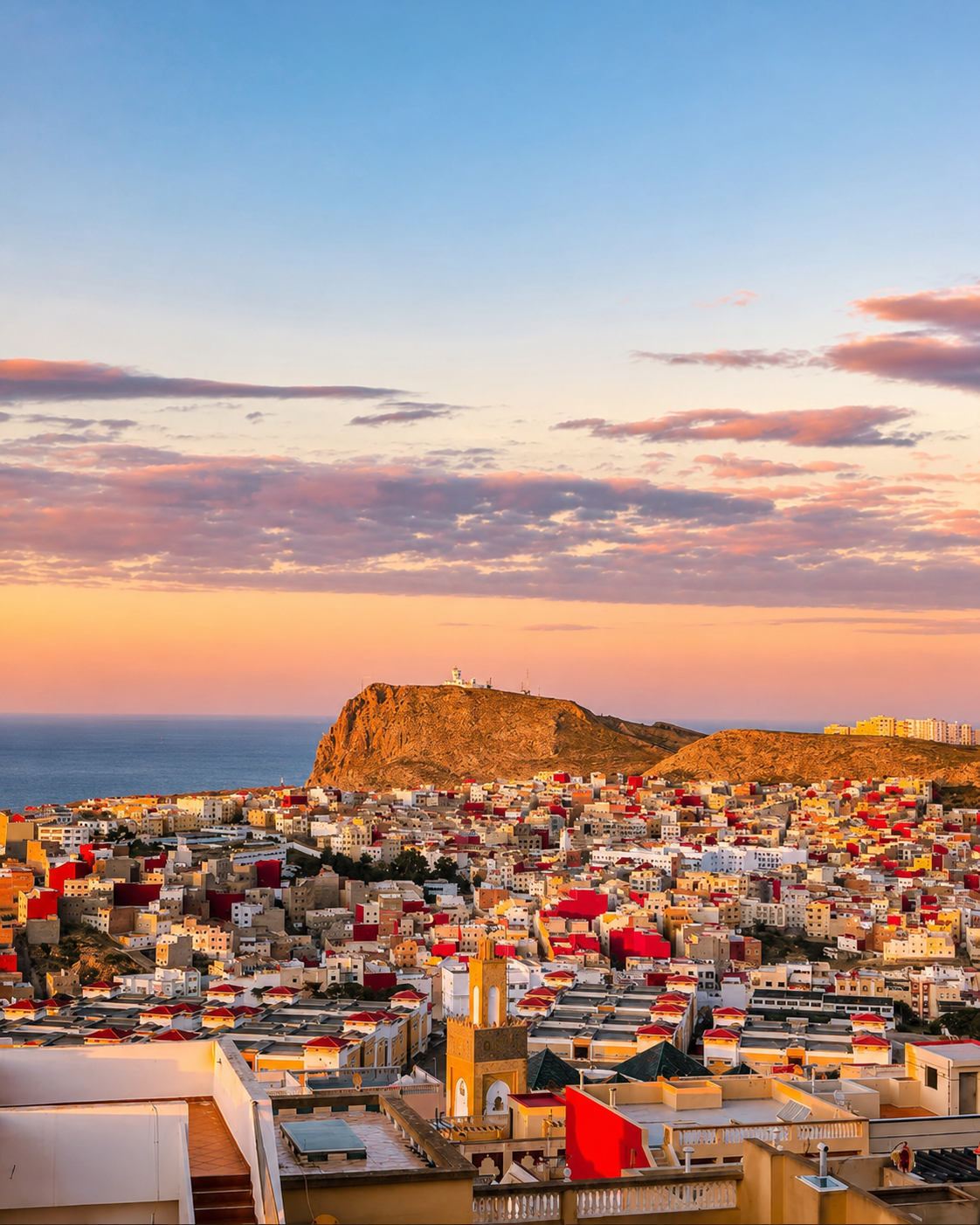
Al Hoceima city at sunset above the Mediterranean, the guide context for Quemado Beach

Go deeper through the nearest city context

Al Hoceima - the city gateway to Quemado Beach

Quemado Beach belongs naturally inside an Al Hoceima journey. The city gives visitors the right context for reading the bay: waterfront viewpoints, port movement, compact streets, Mediterranean light and the surrounding Rif relief.

Use Al Hoceima to widen the visit after the beach itself. The city helps connect Quemado to nearby coves, national-park landscapes, coastal roads, evening viewpoints and the particular rhythm of Morocco's northern Mediterranean shore.

City and waterfront orientationAl Hoceima beach context Port and bay viewpointsRif coastline reading Practical travel structureNearby coastal highlights

Continue the journey

Continue from Quemado Beach into Al Hoceima.

Read the bay slowly, then connect it to Al Hoceima, the port, the Rif coast, nearby coves and Morocco's wider Mediterranean travel map.