Banasa Roman streets, river light and quiet ruins in Morocco's Gharb
Banasa is a Roman-period archaeological site near the Sebou River, where forum stones, house foundations, temple remains and planned streets make ancient urban life readable in open landscape.
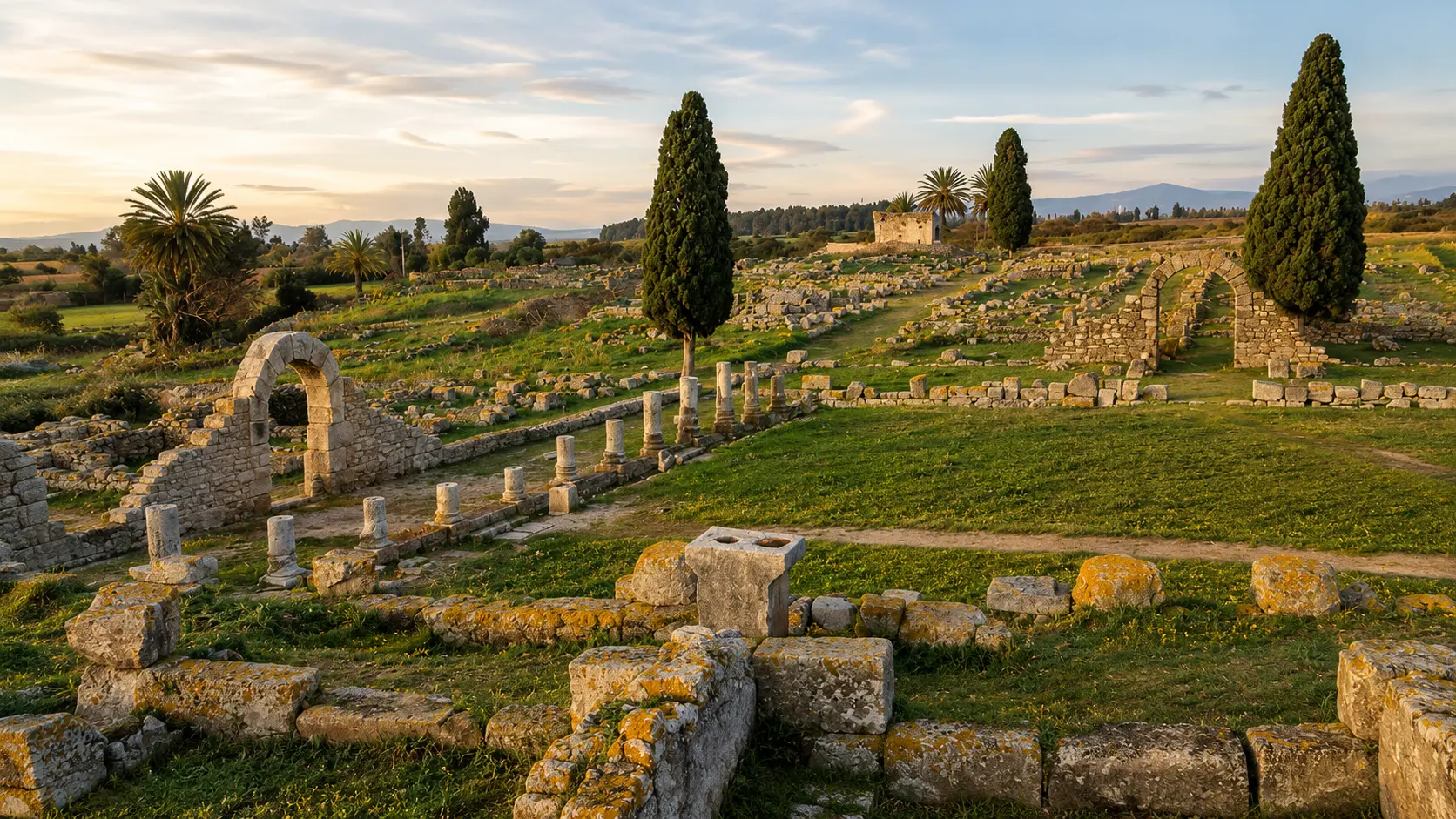
Begin with the whole field of ruins. Banasa is not a single monument competing for attention; it is a city plan, a river-plain setting and a collection of surviving fragments that reward patient looking.
Banasa matters because it lets visitors read ancient Morocco through urban order rather than spectacle. The surviving site is low, open and quiet, but its remains still point to a planned Roman-period town: civic space, domestic quarters, street axes, temple context and stone fragments arranged across the Gharb plain.
Visit Rabat describes Banasa as a valuable testament to Roman urban planning, highlighting the forum, Roman houses, temple remains and the grid-patterned streets of the cardo and decumanus. That gives the visitor a strong reading method: do not look for only one dramatic landmark; follow the organisation of the whole site.
The location matters as much as the masonry. Banasa belongs to the Sebou River and Gharb landscape, a fertile lowland setting that makes the ruins feel different from Morocco's hilltop monuments and walled medinas. Here, archaeology is spread across open ground, with vegetation, horizon and river country shaping the atmosphere.
The site is also a reminder that Roman Morocco was not only monumental stone. It was administration, housing, ritual, streets, storage, trade and everyday movement. Banasa makes those systems visible through foundations, columns, broken walls and alignments that ask visitors to reconstruct the city carefully rather than consume it quickly.
For a premium visit, the strongest experience is slow and precise. Read the forum as civic space, the streets as movement, the houses as social fabric, the temple remains as public religion and the surrounding plain as part of the site's meaning. Banasa becomes powerful when the gaps are respected.
Use the map first to place Banasa in the Gharb plain near the Sebou River, with Kenitra as the clearest city context for planning and orientation.
Editorial reading
Its quiet is part of the evidence.
Banasa does not announce itself with a single intact facade. Its intelligence is horizontal: paving, foundations, column bases, wall lines, thresholds and the way routes cross the ground. The visitor has to look like a reader, not only like a photographer.
This makes the site unusually rewarding for people who enjoy historical places without theatrical staging. The eye moves from stone to grass, from arch fragment to street line, from open sky to civic layout. Each small survival helps restore the larger pattern of the ancient town.
The best reading also accepts absence. Many structures are no longer complete, and that incompleteness should not be filled with fantasy. Banasa is strongest when the visitor lets the evidence remain partial, then uses orientation, proportion and setting to understand what the ruins can still say.
Its beauty comes from restraint: warm stone, evening light, cypress silhouettes, low walls and the calm of a site surrounded by agricultural landscape. Nothing needs to be exaggerated. The archaeology, the plain and the river context already carry the atmosphere.
A careful visit keeps public life, domestic life and landscape together. The forum is not just a square, the houses are not just foundations, and the temple remains are not just isolated stones. Together they form a map of how a Roman-period city ordered movement, status, ritual and daily routine.
Banasa therefore belongs naturally in a wider northern Morocco heritage journey. It can be read alongside other ancient and coastal histories, but it should not be treated as a substitute for them. Its particular strength is the lowland clarity of its plan and its quiet relationship with the Sebou basin.
Historical and heritage orientation
Read the site through urban planning, river country and layered evidence.
Banasa, known in ancient references as Iulia Valentia Banasa, is a Roman-period archaeological site in northwest Morocco. The most reliable visitor reading begins with what survives on the ground: civic space, street axes, residential areas, temple remains, architectural fragments and the landscape of the Gharb plain around them.
01Place type
Archaeological site
Banasa is best approached as an ancient urban site rather than a single monument. Its meaning comes from the relationship between public space, housing, streets, ritual buildings and landscape.
02Ancient context
Mauretania Tingitana
Archaeological references place Banasa within the Roman province of Mauretania Tingitana, the northwest African context that also helps explain its civic layout and administrative character.
03Urban frame
Forum and street axes
Visitor and archaeological descriptions highlight the forum, house remains, temple area and grid-patterned streets. These features make the site especially useful for understanding Roman urban planning in Morocco.
04How to read it
Evidence over legend
The ruins are evocative, but the strongest interpretation stays close to what can be seen or verified. Banasa rewards careful observation of fragments, alignments and material traces.
A visual bridge
Three readings between river plain, stone and street
Before Banasa becomes a photograph, it is a pattern on the ground. These three readings help visitors move beyond ruin-spotting and understand the site as an ancient town shaped by plan, material and lowland setting.
01
Ground
City plan at walking pace
The ground is the first archive. Street alignments, foundations and open civic space help the visitor rebuild the logic of the town without pretending that every missing wall can be recovered.
Follow alignments before chasing details.
Read gaps as part of the archaeological experience.
Let the plan explain the visible fragments.
02
Landscape
Sebou and Gharb context
Banasa sits within a lowland environment where river country, fertile ground and open horizon shape the atmosphere. The setting gives the ruins their calm and helps explain why place, route and land belong together.
Keep the plain in view while walking.
Notice how low stones meet vegetation and sky.
Connect the site to the wider Sebou basin.
03
Evidence
Fragments with discipline
The richest visit does not force the ruins into a finished picture. It observes what remains: stones, bases, thresholds, house lines, public space and the rhythm of the ancient streets.
Look for joins between civic and domestic areas.
Use shadows to read depth and edges.
Photograph respectfully without moving stones.
Quick orientation
Type of place
A Roman-period archaeological site, best understood through civic ruins, street logic, domestic traces and the wider urban plan rather than one isolated monument.
Landscape context
Banasa belongs to the Gharb plain and Sebou River environment, where open lowland, agriculture, vegetation and horizon shape the visual reading.
Best for
Roman urbanism, archaeological walking, quiet photography, heritage interpretation, slow observation and a less obvious northern Morocco place route.
Closest city context
Kenitra is the clearest city context for travellers who want to connect Banasa with the wider Rabat-Sale-Kenitra region and the Atlantic-Sebou corridor.
What visitors experience here
A place that becomes clearer as you slow down.
Banasa feels open before it feels monumental. The first impression is landscape: grass, low stones, cypress forms, broken arches, column fragments and warm light across the plain. The deeper experience comes when those fragments begin to align into streets, civic spaces and domestic areas.
Arrival
An open field of evidence
The site does not compress itself into a single entrance drama. It opens gradually, with stones spread across ground that asks the visitor to assemble the ancient town through careful movement.
Light
Warm stone and green plain
Early or late light can make the site especially readable: shadows reveal wall lines, columns gain relief, and the contrast between pale stone, grass and sky gives the ruins a calm authority.
Movement
Street logic underfoot
Walking Banasa means paying attention to direction. The site becomes stronger when visitors follow the sense of streets, crossings and civic zones rather than moving randomly from fragment to fragment.
Material
Fragments with weight
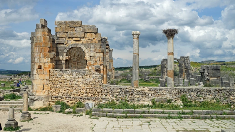
Column drums, blocks, thresholds and broken arches carry more meaning than their size suggests. They are not decoration; they are surviving clues to building systems, public space and urban memory.
Civic space
The forum as anchor
The forum area gives the visit structure. It helps the eye understand how public life, administration, movement and ceremony were organised in the ancient city.
Pace
A quieter kind of place
Banasa rewards visitors who accept stillness. The atmosphere is not empty; it is archaeological, rural and lowland, with meaning held in alignments, surfaces and what remains visible in the landscape.
Place details and orientation
Read Banasa through six defining elements
No single detail explains Banasa. Its meaning comes from the relationship between forum, streets, houses, temple remains, architectural fragments and the river-plain landscape around the site.
1
Forum area
The civic heart helps visitors understand Banasa as an organised town, not a scattered set of isolated ruins.
2
Street axes
The cardo and decumanus logic gives the site its urban grammar: north-south and east-west movement made visible through the ground plan.
3
Roman houses
House foundations bring domestic life into the reading, especially where visitor descriptions connect Banasa to mosaic-bearing residential spaces such as the House of the Seasons.
4
Temple remains
The temple context keeps public religion and civic identity within the visit, balancing domestic traces with formal public space.
5
Architectural fragments
Columns, blocks and arch remains give scale to buildings that no longer stand complete, helping the visitor imagine volume without inventing it.
6
Gharb plain setting
The open lowland landscape is part of the experience. Banasa should be read with vegetation, horizon, river country and agricultural calm around it.
Archaeology, not spectacle
The page becomes stronger when the gaps are respected.
Start by locating the forum and the main street logic. Once those anchors are clear, the smaller remains become easier to understand: house lines, thresholds, columns, broken masonry and edges that suggest rooms, movement and public life.
Then step back. Banasa is not only a collection of ancient stones; it is a relationship between human planning and lowland setting. The plain softens the ruins visually, but it also helps explain why the site feels broad, open and unusually quiet.
Good interpretation does not overfill the missing parts. Let the remains stay partial. Banasa teaches visitors to read evidence with patience, to notice scale without drama and to treat archaeological silence as part of the encounter.
Architecture and material intelligence
Stone, plan and plain do the work.
Banasa's architectural intelligence is not only in surviving columns or arches. It is in the way the city plan can still be sensed from the ground: public space, street direction, domestic zones and ritual architecture forming a readable urban system.
The materials matter because they sit exposed within the landscape. Blocks, bases, thresholds and wall lines change with light and vegetation, turning the site into a lesson in archaeology as observation: not polished reconstruction, but evidence held in place.
What to notice slowly
Begin with the street axes before focusing on individual fragments.
Use the forum area as the main civic anchor for the visit.
Notice how house foundations shift the site from monument to lived city.
Read columns, bases and broken arches as scale markers.
Keep the Gharb plain and Sebou context in view; the setting is part of the site's meaning.
Do not move stones, climb on fragile masonry or treat archaeological remains as props.
Architectural reading
Three urban languages to notice
Civic order
The forum and public monuments give Banasa its civic grammar. They help visitors see the ruins as organised public life rather than scattered fragments.
Domestic scale
House remains change the emotional scale of the site. They bring the visitor from city planning into ordinary rooms, thresholds and the patterns of daily movement.
Landscape frame
The Gharb plain keeps the architecture open to light, vegetation and horizon. Banasa's atmosphere depends on this lowland frame as much as on its stone remains.
Visual atmosphere
Light, fragments and quiet transitions
From distance to alignment
Start with the whole archaeological field, then look for the lines that organise it. Banasa becomes clearer when fragments stop feeling random and begin to read as streets, rooms and civic edges.
From stone to vegetation
The meeting of masonry, grass, cypress, palms and open sky gives the site its quiet visual tone. The landscape does not distract from the ruins; it helps make their low forms legible.
From image to memory
A strong photograph may catch the arches and warm light, but the deeper memory comes from reconstructing the town mentally: forum, streets, houses, temple remains, fragments and plain held together in one careful reading.
Nearby places and onward links
Connect Banasa to Morocco's northern heritage map
Banasa belongs naturally to a wider Rabat-Sale-Kenitra and northern heritage route. Kenitra gives the practical city context, while the broader Atlantic and heritage themes help visitors connect archaeology, coast, river and urban history.
Kenitra
The strongest city context for Banasa, useful for connecting the archaeological site with the Sebou corridor, Atlantic edge and regional travel planning.
Banasa is a clear gateway into Morocco's archaeological depth: urban planning, civic remains, Roman-period material culture and responsible heritage reading.
Banasa is open and atmospheric, which can make the ruins feel informal. They are not. Move carefully, stay aware of fragile masonry, avoid climbing on walls or blocks, and never shift stones for a photograph.
Respect also means accepting the pace of the place. Archaeological sites become damaged through small careless actions: standing on edges, scratching surfaces, leaving litter, entering restricted areas, or treating fragments as casual props. A slower visitor sees more and harms less.
Keep to appropriate walking lines and avoid pressure on fragile walls or edges.
Do not move stones, climb on masonry, scratch surfaces or remove fragments.
Ask before photographing local people, workers, guides or private moments near the site.
Carry water and sun protection; the open plain can feel exposed in strong light.
Check current access, local guidance and practical arrangements close to travel.
A strong first visit
Begin with the map, then orient yourself on the ground. Banasa becomes much easier to read when you understand that the main experience is spatial: civic centre, street axes, houses, temple remains and scattered architectural fragments forming an ancient urban plan.
Walk slowly enough to let alignments appear. Pause where the forum space becomes legible, then move outward toward domestic traces and fragments. The best rhythm is not fast coverage; it is a patient loop that connects plan, stone and landscape.
If you arrive with a guide, listen for terms that clarify the site: Iulia Valentia Banasa, Mauretania Tingitana, forum, cardo, decumanus, temple, residential quarter and Sebou context. These words help organise what the eye is seeing.
Afterward, connect the visit to Kenitra and the wider Rabat-Sale-Kenitra region. That context helps Banasa feel less like an isolated ruin and more like part of a broader Moroccan landscape of river routes, coast, agriculture and layered history.
Start with orientation: map, landscape, then site plan.
Use the forum and street axes as anchors for everything else.
Let house remains bring the ancient town back to human scale.
Photograph from stable ground without touching or rearranging remains.
Finish by connecting Banasa back to Kenitra and the wider Sebou-Gharb context.
Careful planning note: opening hours, prices and exact travel times can change. Verify practical arrangements locally before travelling.
Go deeper through the nearest city context
Kenitra - the city context for Banasa
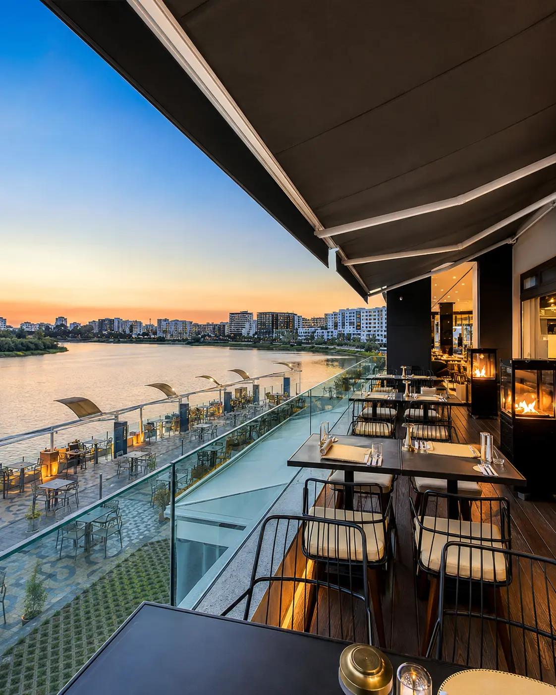
Banasa belongs naturally inside a wider Kenitra and Gharb journey. The city gives visitors a practical base for reading river country, Atlantic proximity, agricultural plain, modern urban life and the quieter archaeological places around the region.
Use Kenitra to widen the context after Banasa itself. The contrast is useful: ancient civic order in the open plain, then a modern regional city shaped by movement, water, roads and everyday life. Together they make the site feel connected rather than remote.
Kenitra city orientationGharb plain contextSebou River readingArchaeology and heritagePractical travel baseAtlantic-region links
Continue from Banasa into Morocco's northern heritage map.
Read the ruins slowly, then connect them to Kenitra, the Sebou River, the Gharb plain, archaeological heritage and the wider cultural geography of Morocco.