
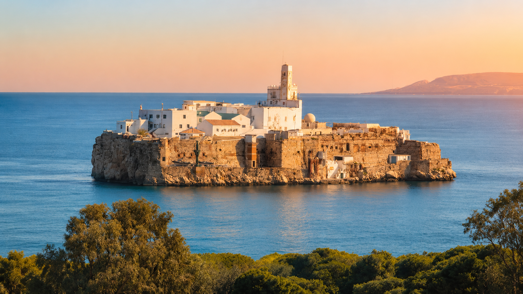
Sfiha Beach on the Rif coast near Al Hoceima, with blue Mediterranean water and offshore rocky islets

Visit / Place · Al Hoceima Bay · Rif coast

Sfiha Beach A Mediterranean beach where Rif cliffs, blue water and offshore islets meet

Sfiha Beach, also written Asfiha, sits in the Al Hoceima coastal landscape where the beach experience is shaped by open water, rocky slopes, family rhythm and the unmistakable offshore islets.

Begin from the approach above the shore. The strongest first reading is not only the sand, but the full composition: calm Mediterranean blue, steep Rif rock, a broad beach line and the small island silhouette holding the horizon.

Why Sfiha Beach matters

A beach before it is a view.

Sfiha Beach matters because it makes the Al Hoceima coast readable in one calm frame. The beach is not separated from its surroundings: the water, slope, rock, road approach, cafes, summer families and offshore islets all work together to define the place.

The Moroccan National Tourist Office includes Asfiha among the beaches of Al Hoceima, a coastal area promoted for wild beaches, natural sites and clear blue water. That broader context is important. Sfiha is part of the Rif coast experience, not a generic resort strip that could belong anywhere.

The beach also matters visually. From the shore and higher approaches, the eye moves across a long waterline toward the rocky forms offshore in Al Hoceima Bay. Those island shapes give the beach a strong horizon marker and turn a simple swim stop into a place of orientation.

Sfiha is close enough to Al Hoceima and Ajdir to feel accessible, yet the setting still carries the drama of northern Morocco's Mediterranean edge. The visitor reads city context and coastal landscape together: white buildings, dry slopes, blue water and the changing light of the bay.

For visitors, the richest experience comes from slowing down. Notice where the water changes tone near the shore, how the beach fills differently by season, where families gather, where cliffs tighten the view, and how evening light turns the offshore forms into a quiet visual anchor.

Core orientation is grounded in the Moroccan National Tourist Office beach guidance for Al Hoceima and open map references for Plage Sfiha. Practical details such as services, swimming conditions and access arrangements should be checked close to travel.
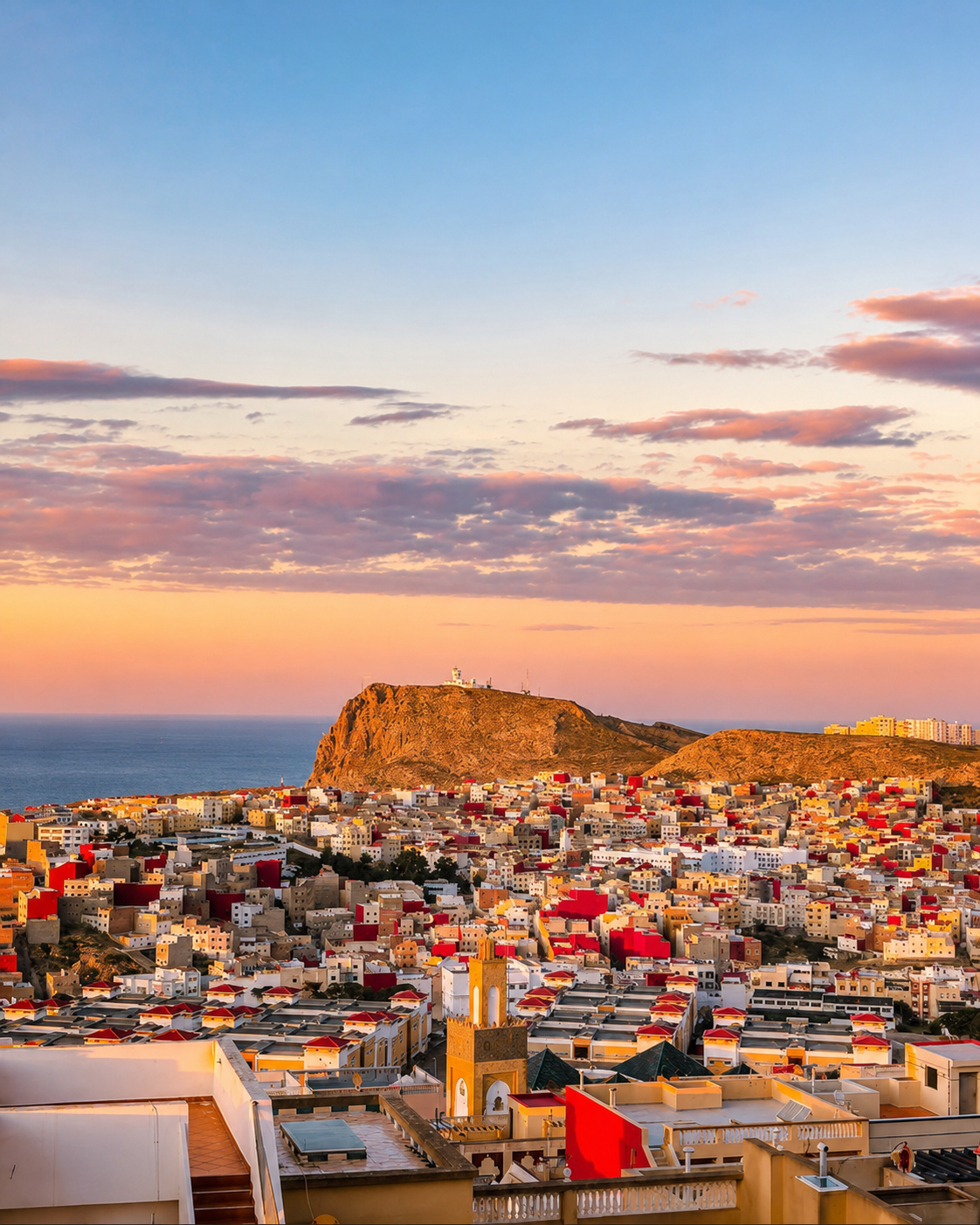
Al Hoceima city rising above the Mediterranean coast, the urban context for Sfiha Beach

Map orientation

Use the map to place Sfiha on the Al Hoceima coast, close to Ajdir and facing the bay rather than the city centre itself.

Editorial reading

Its beauty is coastal, not decorative.

Sfiha is strongest when read as a meeting point. The beach line gives openness, the Rif slopes give enclosure, the bay gives distance and the offshore islets give the eye a fixed point beyond the water.

That balance is why the place rewards more than a fast swim. From above, the beach reads as a curve held between rock and sea. From the sand, the same landscape becomes softer: umbrellas, families, small boats, cafe terraces, wave sound and the low shine of Mediterranean light.

The beauty is not only colour. It comes from proportion: broad water beside steep land, small human movement against a large bay, and a horizon that feels unusually close because the offshore rocks interrupt the emptiness.

Sfiha also asks for seasonal intelligence. In summer it can be lively and crowded; outside peak moments it can feel more spacious and observational. The page therefore treats the beach as a living public place rather than a staged empty postcard.

Look slowly at the edges. The most telling details are where people choose shade, where the shoreline changes texture, where rocks frame the cove and where the light moves from clean blue into warmer evening tones.

A careful visitor leaves with more than a beach photograph. The memory should include how Al Hoceima's coast holds contrast: bright water and dry slope, leisure and landscape, city access and a horizon shaped by small islands.

Coastal and visitor orientation

Read the beach through bay, slope and public rhythm.

Sfiha Beach is a Mediterranean beach in Al Hoceima Province, in the Tanger-Tetouan-Al Hoceima region of northern Morocco. Its identity comes from more than sand: the bay, nearby Ajdir context, Rif slopes, open water and offshore Alhucemas islets all shape how the place is seen and used.

01Place type

A Mediterranean beach

Sfiha, often written Asfiha in tourism material, is best understood as a coastal place: swimming beach, viewpoint, family leisure space and bay-facing landscape in one setting.

02Coastline

Rif slope and open water

The beach belongs to the northern Rif coast, where steep land meets the western Mediterranean. That relationship gives the view its scale and keeps the shoreline visually tied to the mountains behind it.

03Horizon

Offshore Alhucemas islets

The small rocky forms visible offshore are part of the bay's visual identity. They should be read as horizon markers: strong enough to define the view, but best handled with careful, neutral language.

04Seasonal use

A public beach rhythm

Sfiha can feel very different by season and time of day. Summer brings more umbrellas, families and services; quieter moments make the waterline, rocks and light easier to read.

A visual bridge

Three readings between water, slope and horizon

Before Sfiha becomes a beach photograph, it is a relationship between Mediterranean water, Rif geology and the horizon of Al Hoceima Bay. These three readings help visitors slow down and understand why the place feels open and framed at the same time.

01

Water

The blue gradient

The first lesson is water. Close to shore, colour can shift from pale turquoise to deeper blue, making the bay feel calm without becoming flat. Watch the change before choosing where to sit or photograph.

  • Read colour changes near the shoreline.
  • Notice how light changes the same water through the day.
  • Keep swimming conditions separate from how calm the view looks.
02

Slope

Rif rock as frame

The coastline gives Sfiha its shape. Rock, dry vegetation and steep approaches frame the beach so the visitor never reads it as open sand alone. The land is part of the view, not background decoration.

  • Look at how cliffs hold the beach edge.
  • Use higher viewpoints before going down to the shore.
  • Stay cautious around slopes, loose ground and exposed edges.
03

Looking

Horizon before detail

The offshore islets give Sfiha a distinctive horizon. Begin with that wide composition, then let the details arrive: umbrellas, small boats, cafe terraces, rock texture, changing wind and the human pace of the shore.

  • Start with the whole bay.
  • Move from high view to beach level slowly.
  • Photograph the place without crowding private moments.

Quick orientation

Type of place

A Mediterranean beach and coastal viewpoint near Ajdir, with broad shoreline access and a strong view toward the offshore Alhucemas islets.

Landscape context

Sfiha belongs to the Al Hoceima bay landscape, where blue water, Rif slopes, rocky edges and nearby city life meet in one readable coastal frame.

Best for

Beach time, sunset light, careful photography, family rhythm, bay views and a softer introduction to the wider Al Hoceima coast.

Closest city context

Al Hoceima is the natural city guide for visitors connecting Sfiha with Quemado, Cala Bonita, nearby coves and northern Rif travel planning.

What visitors experience here

A beach that changes with distance, light and season.

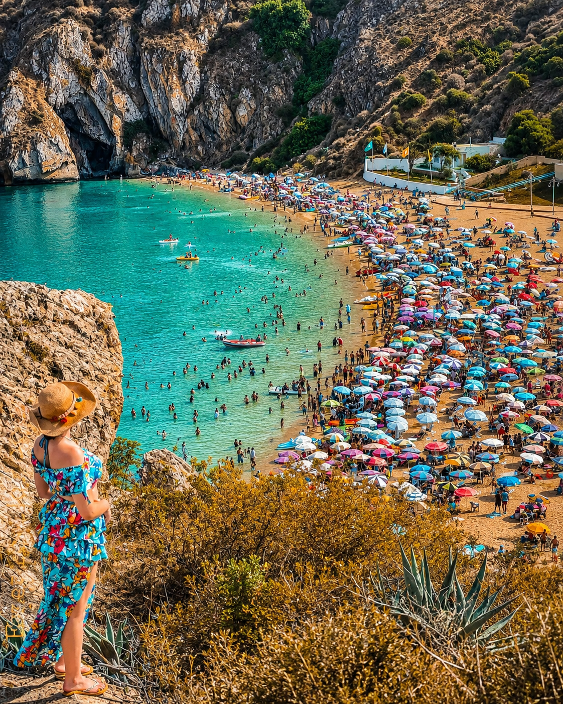
Sfiha works in stages. First comes the overview from above: a clean sweep of water, beach and rock. Then comes the human scale: umbrellas, families, cafes, small boats, shoreline texture and the sound of waves moving across the bay.

Arrival

The bay from above

The strongest arrival view is elevated. Before the beach becomes busy at eye level, the whole shape appears: water, sand, rock and a horizon interrupted by the offshore islets.

Water

Clear colour close to shore

The water is central to the mood. Its colour changes with depth, sun and wind, so a visitor should read the sea patiently rather than assuming every blue surface means the same conditions.

Beach life

A public summer rhythm

In busier periods, Sfiha becomes animated by families, umbrellas, cafes and beach services. That liveliness is part of the place, but early and late hours often give the landscape more room to breathe.

Horizon

The offshore silhouette

The Alhucemas islets give the beach a visual signature. They make the horizon feel close and specific, especially when the sun lowers and the rocky forms become more graphic.

Texture

Rock, sand and dry vegetation

The coast around Sfiha is not polished flat. Dry slopes, rock faces, scrub and sand sit beside the water, giving the beach a northern Moroccan texture that feels connected to the Rif.

Pace

A slower shoreline visit

The best rhythm is simple: arrive with the wide view, settle near the water, walk the edge, watch the light change, then reconnect the beach to Al Hoceima rather than treating it as an isolated stop.

Place details and orientation

Read Sfiha Beach through six defining elements

No single detail explains Sfiha. Its meaning comes from the relationship between the beach line, bay water, Rif slope, offshore horizon, nearby Al Hoceima context and the seasonal pressure of a loved public shore.

1
The beach line

The long shoreline gives Sfiha its openness. Read it as a public coastal space before reducing it to a single viewpoint or swim stop.

2
The bay water

Blue water is the dominant visual force, but it changes with depth, wind and light. Observe conditions locally before swimming.

3
The Rif slope

Rocky slopes and dry vegetation give the beach its frame. They also make higher viewpoints powerful and exposed edges worth treating carefully.

4
The island horizon

The offshore Alhucemas islets are the most distinctive horizon element, turning the bay into a recognisable Al Hoceima scene.

5
Ajdir and Al Hoceima context

The beach is tied to nearby urban and village life, so its rhythm is social as well as scenic: arrivals, cafes, families and evening movement.

6
Seasonal pressure

Sfiha can carry heavy summer use. Good visits respect the shore by reducing litter, noise, intrusive photography and pressure on fragile edges.

Coast, not scenery

The place asks for a patient eye.

Stand above the beach before going down. The first lesson is spatial: a bay held by rock, a shoreline wide enough for public life, and an offshore silhouette that gives the view its centre.

Then move closer. Sand, wave sound, umbrellas, cafe movement, swimming areas and shoreline texture make the place human. This is where Sfiha becomes more than a panorama: the visitor begins to understand how local leisure and landscape share the same space.

Look for the relationship between beach level and the higher approach. The elevated view gives order; the shore gives feeling. Together they turn Sfiha into one of the clearest visual introductions to Al Hoceima's Mediterranean coast.

Landscape and coastal intelligence

The beach works because water, slope and city edge stay in conversation.

Sfiha's visual character is not just a bright-water effect. The beach works because the Mediterranean, Rif slope, nearby Al Hoceima context and offshore rocks all remain visible at once. Remove any one of those elements and the place becomes less legible.

This is why the best visit uses both distance and detail. From above, Sfiha explains the bay. From the shore, it explains public rhythm: where people gather, how services appear by season, how light softens the cliffs and how the sea changes mood without changing the identity of the place.

What to notice slowly

  • Look at the entire bay before focusing on beach details.
  • Notice how the water changes colour with depth, wind and time of day.
  • Read the offshore islets as part of the horizon, not as a detached curiosity.
  • Use the Rif slope to understand why the beach feels framed rather than endless.
  • Keep Al Hoceima in view as the nearest urban travel context.
  • Respect crowded public space, family privacy and the shoreline's cleanliness.

Visual reading

Three coastal languages to notice

Curve and enclosure

Sfiha speaks first through its curve: the beach opens to the bay while the slopes hold the composition. The result is spacious without feeling empty.

Water and horizon

The eye moves naturally from shore colour to deeper blue, then toward the offshore islets. That layered view gives Sfiha its most recognisable visual rhythm.

Public rhythm and restraint

Beach life is part of the scene, especially in summer. The respectful visitor enjoys that energy without photographing strangers intrusively or adding pressure to a busy shoreline.

Visual atmosphere

Blue water, pale rock and evening warmth

From viewpoint to shoreline

Start with the whole bay from above, then move down to beach level. The shift matters: the landscape becomes less graphic and more tactile as sand, water sound and human movement enter the frame.

From rock to sea

The strongest contrast is not artificial saturation, but the meeting of dry Rif rock, pale beach tones and Mediterranean blue. Let the colour stay natural; Sfiha does not need exaggerated treatment to feel vivid.

From photo to memory

The image is powerful, but the deeper memory comes from connecting the water to the horizon, the beach to Al Hoceima and the view to the everyday public life of the coast.

Nearby places and onward links

Connect Sfiha to the wider Al Hoceima coast

Sfiha belongs to a broader northern Mediterranean itinerary. Al Hoceima gives the clearest city context, while nearby beaches, coves and Rif landscapes turn a single beach visit into a fuller coastal reading.

Al Hoceima

The closest city context for Sfiha Beach. Use it to frame the bay, the port city rhythm, nearby beaches and the wider Rif coastline.

Open Al Hoceima city guide

Quemado Beach

A more urban Al Hoceima beach setting, useful for comparing Sfiha's open bay feeling with the city's closer waterfront energy.

Open Quemado Beach

Al Hoceima National Park

The broader protected coastal landscape helps visitors read cliffs, coves, marine colour and Rif nature beyond a single beach day.

Explore the park

Cala Iris

Continue west along the Mediterranean coast for another Rif shoreline reading, with a different scale of village, cove and horizon.

Open Cala Iris

Northern Morocco & Rif

Use the regional route to connect Sfiha with Rif mountains, Mediterranean towns, coastal roads and northern Morocco's layered travel map.

Explore the region

Plan your journey

Treat Sfiha as part of an Al Hoceima coast plan, not a detached beach stop. Build time for light, access, swimming conditions and nearby routes.

Plan your journey

How to visit respectfully

Good beach behaviour protects the place.

Sfiha is a public beach, not a private stage. Give space to families, avoid photographing people closely without permission, keep music and noise considerate, and remember that local beach life is part of the place's identity.

Respect also means caring for the shoreline. Do not leave litter, disturb rocks or plants on the slopes, crowd small access points, or treat exposed viewpoints casually. Water, wind and cliffs can change the practical feel of a visit even when the scene looks calm.

  • Ask clearly before photographing families, vendors, swimmers or private moments.
  • Keep the shore clean and carry small waste back if bins are full or unavailable.
  • Use established paths and stay cautious around slopes, rocks and exposed viewpoints.
  • Support nearby cafes and local services with courtesy and fair-minded interaction.
  • Check current access, weather, sea conditions and local guidance close to travel.

A strong first visit

Begin above the beach if you can, where the full bay, shoreline and offshore islets are easiest to understand. That first view gives the visit its structure before towels, umbrellas and close details fill the eye.

At beach level, choose a spot with care. Leave walking room along the shore, keep belongings compact, watch how families use the space, and treat vendors and cafe staff as part of the local rhythm rather than background service.

For photography, work with distance and patience. Wide views of water, slope and island horizon are usually stronger than intrusive close-ups. Late light can be beautiful here, but natural colour is enough; the coast does not need heavy editing to look alive.

Afterward, connect the visit back to Al Hoceima. Sfiha becomes more meaningful when it is read beside Quemado, Cala Bonita, nearby coves and the wider Rif coast rather than isolated as one beach photo.

  • Start with the elevated bay view, then move down to the shoreline.
  • Let the waterline, rocks and island horizon guide the visit's rhythm.
  • Keep beach noise, litter and photography respectful in crowded moments.
  • Use nearby services without turning public space into a private setup.
  • Finish by connecting Sfiha back to Al Hoceima and the wider Rif coast.

Careful planning note: services, parking, sea conditions and seasonal crowd levels can change. Verify practical arrangements locally before travelling.

A turquoise beach cove near Al Hoceima with Rif cliffs and summer shoreline activity

Go deeper through the nearest city context

Al Hoceima — the city gateway to Sfiha Beach

Sfiha Beach belongs naturally inside a wider Al Hoceima journey. The city gives visitors a stronger base for reading the bay: port life, white hillside buildings, beaches, rocky coves, Rif slopes and the soft drama of the Mediterranean edge.

Use Al Hoceima to widen the context after Sfiha itself. Nearby waterfronts, coastal viewpoints, cafes, evening walks and onward routes make the beach feel less like a single stop and more like one chapter in northern Morocco's coast.

Bay and city contextAl Hoceima orientation Nearby beaches and covesRif coastal viewpoints Practical travel structureMediterranean route ideas

Continue the journey

Continue from Sfiha Beach into the Al Hoceima coast.

Read the bay slowly, then connect Sfiha to Al Hoceima, nearby beaches, Rif slopes, Mediterranean light and the wider northern Morocco map.